logo

1930. A Map of Santa Barbara For Tourists

  • A Map of Santa Barbara For Tourists
  • A Map of Santa Barbara For Tourists

A Map of Santa Barbara For Tourists information:

Year of creation: 
Resolution size (pixels): 
 9832x8162 px
Disk Size: 
 19.744MiB
Number of pages: 
 2
Place: 
 Santa Barbara

Print information. Print size (Width x height in inches):
Printing at 72 dpi 
  136.56 х 113.36
Printing at 150 dpi 
 65.55 х 54.41
Printing at 300 dpi 
 32.77 х 27.21

An example of detailing the file of this map of in a printable high-resolution:

Click to open in high resolution (open in new tab).
Attention! this is just the central piece (central area 960x960 px) of the map file!
This is an example, so that you can see and study the level of detail of a given map. The entire Map will be fully available after payment!

A Map of Santa Barbara For Tourists

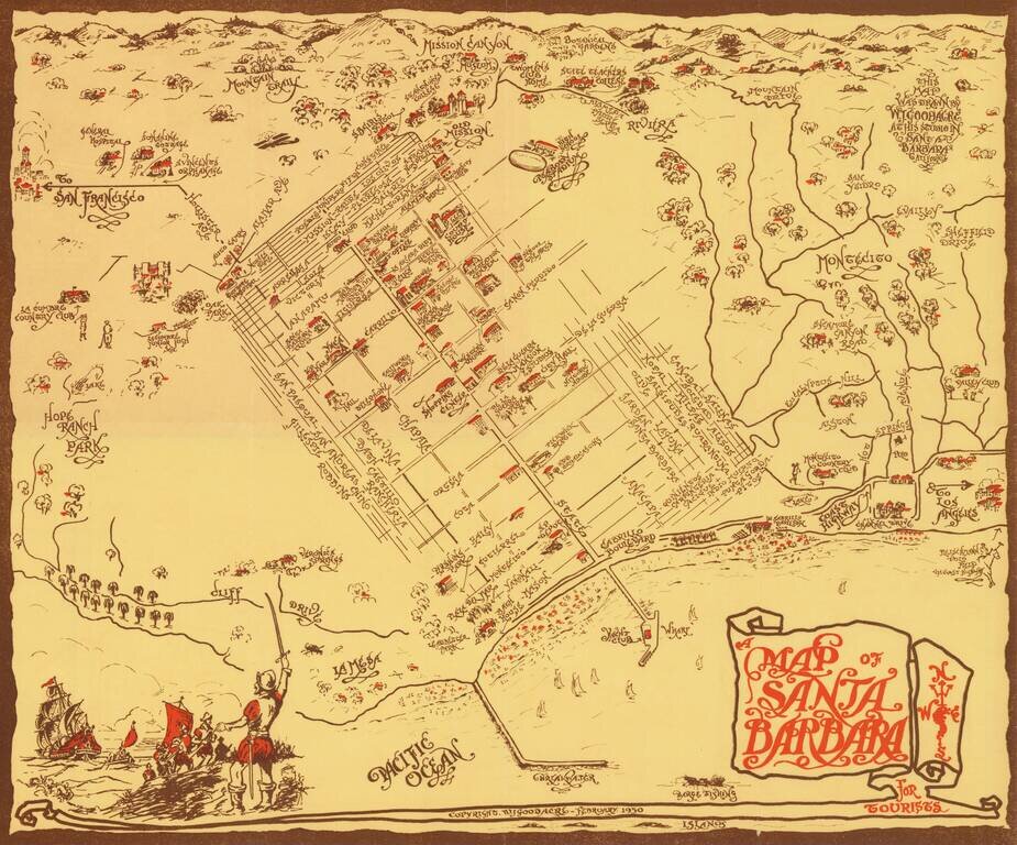
Rare pictorial map of Sant Barbara, drawn by William Johnson Goodacre.

The map offers other interesting historical facts about the state of California.

William Johnson Goodacre was a commercial artist who came to Santa Barbara from England in 1924. He produced a number of interesting maps and book illustrations, including a map entitled "Flag Map of California" and a map entitled "Romance of the Missions."

All of his maps are scarce on the market.


Special conditions for students!

If you are a student, write to us in telegram: @antiquemaps and indicate what material you need and for what work you need a map in high detail. We are ready to provide material on special terms. For students only!

Item information:

Year of creation:
Size:
9832x8162 px
Disk:
19.744MiB
Number of pages:
2
Place:
Santa Barbara
Author:
William Johnson Goodacre.
$14.99

Related item