Map size in jpg-format: 55.3695MiB
Click to open in high resolution (open in new tab).
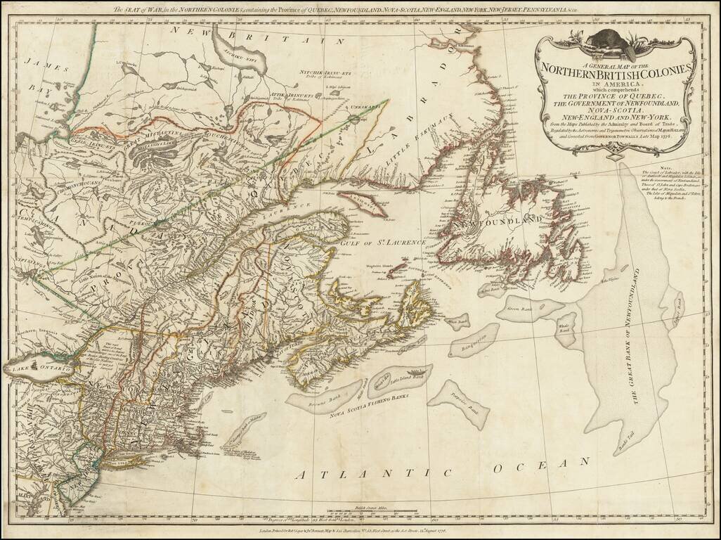
A scarce "Holster Atlas" edition of Sayer and Bennett's highly important map of New England and eastern Canada at the start of the American Revolution. This edition of the map was prepared specifically for the American Military Pocket Atlas, an atlas published for use by British Military Officers during the American Revolution in a size which would fit into the saddlebags of a mounted British Officer.
This map stretches from Maryland to Labrador. The map is extremely detailed, showing many rivers, settlements, geomorphological features, and more. Colonial borders are delineated by dotted lines. In addition, the obsolete borders with French territory are shown. Notes abound on land and at sea, from the navigability of various banks to the disposition of Indian tribes. The large area around the present-day West Canada Lake wilderness is noted as "not yet surveyed," and left blank. This map features a large Maine and Sagahadok, both nearly reaching the Gulf of St. Lawrence.
In all, this is an attractive antique map of the showing American Northeast and parts of Canada at the outbreak of the American Revolution. Includes an attractive cartouche with a decorative beaver placed atop, a reminder of the wealth the colonies could provide.
Robert Sayer (ca. 1724-1794) was a prominent London map publisher. Robert’s father was a lawyer, but his older brother married Mary Overton, the widow of prominent mapmaker Philip Overton and the proprietor of his shop after his death. Mary continued the business for roughly a year after her marriage and then, in early 1748, it passed to Robert. Robert became a freeman of the Stationers’ Company later that year; his first advertisement as an independent publisher was released in December.
Sayer benefited from Overton’s considerable stock, which included the plates of John Senex. In the 1750s, Sayer specialized in design books and topographical prints, as well as comic mezzotints. In 1753, he, along with John Roque, published a new edition of Thomas Read’s Small British Atlas, the first of several county atlases that Sayer would publish.
Sayer’s business continued to grow. In 1760 he moved further down Fleet Street to larger premises at 53 Fleet Street. In 1766, he acquired Thomas Jefferys’ stock when the latter went bankrupt. In 1774, he entered into a partnership with John Bennett, his former apprentice. The pair specialized in American atlases, based on the work of Jefferys. They also began publishing navigational charts in the 1780s and quickly became the largest supplier of British charts in the trade.
Bennett’s mental health declined, and the partnership ended in 1784. As Sayer aged, he relied on his employees Robert Laurie and James Whittle, who eventually succeeded him. He spent more and more time at his house in Richmond. In 1794, he died in Bath.
If you are a student, write to us in telegram: @antiquemaps and indicate what material you need and for what work you need a map in high detail. We are ready to provide material on special terms. For students only!
![[The First Maps in a la poupée Printed Color] Cartes en Couleur des Lieux Sujets aux tremblements de Terre Dans toutes les parties du Monde Selon le Sisteme de l’impulsion Solaire](/map/small/52293op.jpg)

