Map size in jpg-format: 42.107MiB
Click to open in high resolution (open in new tab).
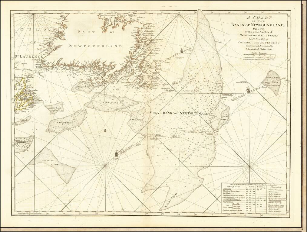
Detailed map of Newfoundland the Grand Banks, published in Jeffery's American Atlas.
The map includes three ship illustrations representing the voyages of Chabert, Cook and Fleurieu, inset of astronomical observations on which the chart is based, as well as depths and rhumb lines.
This edition was published by Robert Sayer and John Bennett in 1775.
This detailed chart of the Grand Banks, Newfoundland, and the entrance to the St. Laurence, was first published in the North American Pilot. Following the end of the French and Indian War, the English were determined to conduct detailed surveys of much of Canada's eastern coastline, as the waterways were deemed of vital economic importance to the inland fur trade. Among those selected for the task was James Cook. On April 19, 1763 James Cook, Master R.N.. was ordered to proceed to Newfoundland 'in order to your taking a survey of the Parts of the Coasts and Harbours of that Island' (Tooley & Skelton, p.177). Cook started by surveying the northwest stretch of coastline in 1763 and 1764, then in 1765 and 1766, the south coast between Cape Ray and the Burin Peninsula, and in 1767, the west coast. Cook's work in the region allowed him to master the art of practical surveying and navigation, bringing his name to the attention of the Admiralty and Royal Society. After Cook returned to England to commence the first of his three great voyages to the Pacific, the survey of Newfoundland and southern Labrador was finished by Michael Lane, between 1768 and 1773. The charting of Newfoundland and southern Labrador by Cook, in the years 1763-7, and by his successor Michael Lane, in 1768-73, was unequalled, for thoroughness and method, by any previous hydrographic work by Englishmen; and it produced the first charts of this extensive and difficult coastline that could (in the words of a later hydrographer) 'with any degree of safety be trusted by the seaman' (Skelton & Tooley). For Cook, his accomplishment led directly to his being commissioned to the Endeavor, launching his reputation as the greatest maritime explorer of his age, and perhaps of all time.
Robert Sayer (ca. 1724-1794) was a prominent London map publisher. Robert’s father was a lawyer, but his older brother married Mary Overton, the widow of prominent mapmaker Philip Overton and the proprietor of his shop after his death. Mary continued the business for roughly a year after her marriage and then, in early 1748, it passed to Robert. Robert became a freeman of the Stationers’ Company later that year; his first advertisement as an independent publisher was released in December.
Sayer benefited from Overton’s considerable stock, which included the plates of John Senex. In the 1750s, Sayer specialized in design books and topographical prints, as well as comic mezzotints. In 1753, he, along with John Roque, published a new edition of Thomas Read’s Small British Atlas, the first of several county atlases that Sayer would publish.
Sayer’s business continued to grow. In 1760 he moved further down Fleet Street to larger premises at 53 Fleet Street. In 1766, he acquired Thomas Jefferys’ stock when the latter went bankrupt. In 1774, he entered into a partnership with John Bennett, his former apprentice. The pair specialized in American atlases, based on the work of Jefferys. They also began publishing navigational charts in the 1780s and quickly became the largest supplier of British charts in the trade.
Bennett’s mental health declined, and the partnership ended in 1784. As Sayer aged, he relied on his employees Robert Laurie and James Whittle, who eventually succeeded him. He spent more and more time at his house in Richmond. In 1794, he died in Bath.
If you are a student, write to us in telegram: @antiquemaps and indicate what material you need and for what work you need a map in high detail. We are ready to provide material on special terms. For students only!
![[The First Maps in a la poupée Printed Color] Cartes en Couleur des Lieux Sujets aux tremblements de Terre Dans toutes les parties du Monde Selon le Sisteme de l’impulsion Solaire](/map/small/52293op.jpg)

