Map size in jpg-format: 543042B
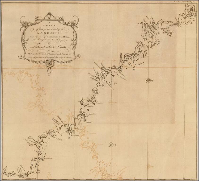
Fine map of the Coast of Labrador, showing the region explored by Roger Curtis, under instructions from Commodore Shuldham in 1773.
Admiral Sir Roger Curtis, 1st Baronet, GCB (1746 - 1816) was an officer of the British Royal Navy, who saw action in several battles during an extensive career that was punctuated by a number of highly controversial incidents. Curtis served during the American Revolutionary War and the French Revolutionary Wars and was highly praised in the former conflict for his bravery under fire at the Great Siege of Gibraltar, where he saved several hundred Spanish lives at great risk to his own. His career suffered however in the aftermath of the Glorious First of June, when he was heavily criticized for his conduct by several influential figures, including Cuthbert Collingwood. His popularity fell further due to his involvement in two highly controversial court-martials, those of Anthony Molloy in 1795 and James Gambier in 1810.
Curtis joined the small brig HMS Otter in Newfoundland in about 1770 and there spent several years operating off the Labrador coastline, becoming very familiar with the local geography and the Inuit peoples of the region. In a report he wrote for Lord Dartmouth, Curtis opined that although the inland regions of Labrador were barren, the coast was an ideal place for a seasonal cod fishery. He also formed a good opinion of the native people, applauding their healthy and peaceful lifestyle. Curtis made numerous exploratory voyages along the Labrador coast and formed close links with the Inuit tribes and Moravian missionaries in the region. His notes and dispatches were presented to the Royal Academy by Daines Barrington in 1774, which included the present map.
Molyneux Shuldham (c. 1717 - 30 September 1798) was an officer of the British Royal Navy. He served for a time as colonial governor of Newfoundland.
The map shows the route of Molyneux Shuldham, the first Baron of Shuldham. On February 14, 1772, Shuldham was appointed commodore and commander-in-chief on the Newfoundland station, which office he held for three years. He was responsible for the construction of Fort Townshend, which was completed in 1780.
Shuldham visited Chateau Bay on the Labrador coast and sent his lieutenant, Roger Curtis, to inspect the northern coast and the Moravian missionaries.
If you are a student, write to us in telegram: @antiquemaps and indicate what material you need and for what work you need a map in high detail. We are ready to provide material on special terms. For students only!
![[The First Maps in a la poupée Printed Color] Cartes en Couleur des Lieux Sujets aux tremblements de Terre Dans toutes les parties du Monde Selon le Sisteme de l’impulsion Solaire](/map/small/52293op.jpg)

