Map size in jpg-format: 42.1776MiB
Click to open in high resolution (open in new tab).
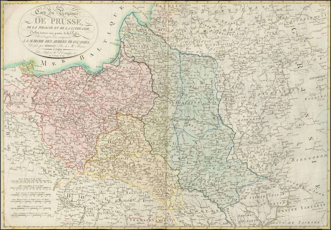
A Rare Map of Poland at the Time of the Creation of the Duchy of Warsaw.
Detailed map of Poland and environs, showing the regions which were the subject of the marches of Napoleon's French Army and its allies, which resulted in the creation of the Duchy of Warsaw.
Although no sovereign Polish state existed between 1795 and 1918, the idea of Polish independence was kept alive throughout the 19th century. There were a number of uprisings and other armed undertakings waged against the partitioning powers. Military efforts after the partitions were first based on the alliances of Polish émigrés with post-revolutionary France. Jan Henryk Dąbrowski's Polish Legions fought in French campaigns outside of Poland between 1797 and 1802, in hopes that their involvement and contribution would be rewarded with the liberation of their Polish homeland.
Towards the end of 1806, the French entered Poland and Napoleon Bonaparte created a new Duchy of Warsaw, to be ruled by his new ally Frederick Augustus I of Saxony. The area of the duchy had already been liberated by a popular uprising that had escalated from anti-conscription rioting. Napoleon then turned north to confront the approaching Russian armies and to attempt to capture the temporary Prussian capital at Königsberg. A tactical draw at Eylau (February 7 and 8, 1807) forced the Russians to withdraw further north. Napoleon then routed the Russian army at Friedland on June 14, 1807. Following this defeat, Alexander sued for peace with Napoleon at Tilsit.
The newly recreated state was formally an independent duchy, allied to France, and in a personal union with the Kingdom of Saxony. However, the duchy was never allowed to develop as a truly independent state; Frederick Augustus' rule was subordinated to the requirements of the French raison d'état, who largely treated the state as a source of resources. The most important person in the duchy was in fact the French ambassador, based in the duchy's capital, Warsaw.
In 1809, a short war with Austria started. Although the Duchy of Warsaw won the Battle of Raszyn, Austrian troops entered Warsaw, but Duchy and French forces then outflanked their enemy and captured Kraków, Lwów and some of the areas annexed by Austria in the Partitions of Poland. During the war the German colonists settled by Prussia during Partitions openly rose up against Polish government. After the Battle of Wagram, the ensuing Treaty of Schönbrunn allowed for a significant expansion of the Duchy's territory southwards with the regaining of once-Polish and Lithuanian lands.
Rarity
This is the first time we have seen this map offered for sale.
If you are a student, write to us in telegram: @antiquemaps and indicate what material you need and for what work you need a map in high detail. We are ready to provide material on special terms. For students only!


![[Hand Drawn Prussian Military Encampment at Opole, Poland] Special Grund-Riss Des Kaeyserl Feldl Lagers bey Oppeln in Ober Schlesien](/map/small/59726.jpg)