
![[First Map of the American Continent] Tavola dell' isole nuove, le quali son nominate occidentali, & indiane per diversi rispetti.](/map/small/67312.jpg)
First Printed Map of the American Continent Early state of Sebastian Münster’s map of America, the earliest to show all of North and South America in a true continental form with a continuous coastline. It is also the first to use Mare Pacificum as...

Fine example of Pierre Mortier's map of the Pacific, which appeared in later editions of the famous Neptune Francois This fine map of the Pacific was drawn from previously unpublished manuscript maps collected by the Portuguese crown and secreted away...
![[Atlantis?] Ristretto Delle Carte presentate all' Academia delle Scienze di Parigi negli anni 1737 e 1752 dal Sig di Buache](/map/small/58667.jpg)
The First Americans Came To America via the Lost Continent of Atlantis?—Rare Italian Map from Work on the Origins of Americans Utilizing The Theories of Philippe Buache Very rare, Italian example of Buache’s theoretical geographic ideas on...
![[New General Map of North and South America Showing the Routes of Kruzenshtern and Lisyansky] НОВАЯ ГЕНЕРАЛЬНАЯ КАРТА СѢВЕРНОЙ И ЮЖНОЙ АМЕРИКИ СЪ ПОКАЗАНІЕМЪ ПУТЕЙ КРУЗЕНШТЕРНА И ЛИСЯНСКАГО](/map/small/58490.jpg)
A Superb Russian Map of the Americas, Made to Highlight the Explorations of Kruzenshtern and Lisyansky in the Pacific. In Alaska, the map notes Lisyansky's landfall on Kodiak Island and at New Archangel (Новоархангелѣскъ, i.e.,...
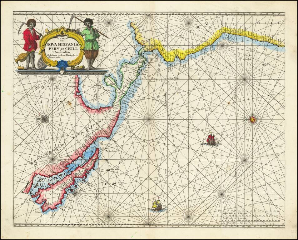
![Pascaart vertoonende de zeecusten van Chili, Peru, Hispania Nova, Nova Granada, en California…. [Early New Zealand Inset]](/map/small/65168.jpg)
Fine Golden Age Dutch Chart with the Island of California and an Early Mapping of New Zealand Scarce early sea chart by Doncker, showing the West Coast of the Pacific Ocean, which extends from the island of California to Chile, with noteworthy insets...
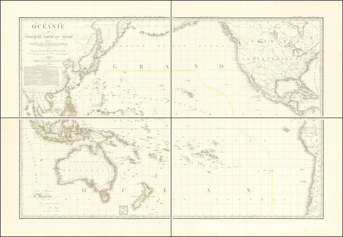
Stunning, Large-Format Map of the Pacific, the Origin of the Toponym Oceania Fine example of A.H. Brué's four-sheet map of the Pacific Ocean, first published in Paris in 1814 and here updated to 1817. The title in the upper left corner indicates...
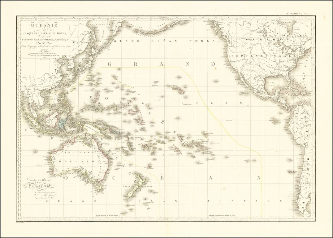
Striking Map of the Pacific, the Origin of the Toponym Oceania Fine example of A.H. Brué's distinctive map of the Pacific Ocean, first published in Paris in 1814 and here updated to 1816. The title in the upper left corner indicates that this map...
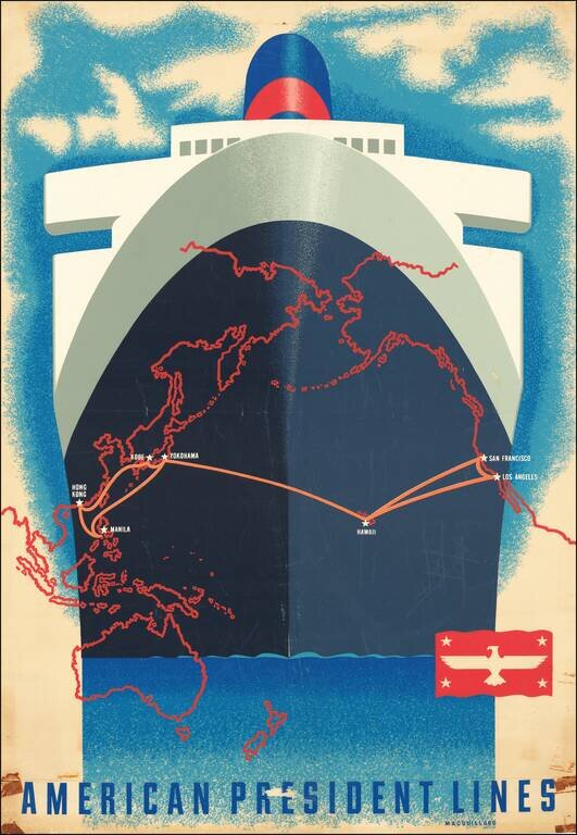
A San Francisco native, Macouillard was an accomplished artist, having studied at the California College of Arts and Crafts and the Art Students League of New York. He became Art Director of the Velvetone Poster Company in San Francisco and designed...
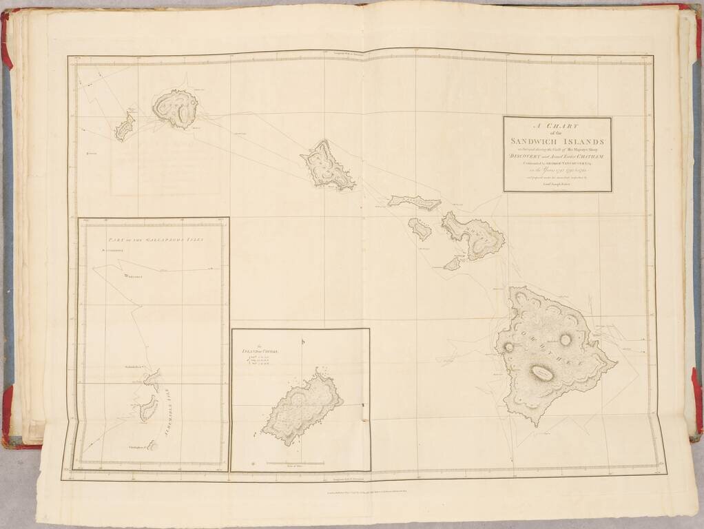
First Edition of Vancouver's Voyage of Discovery with Atlas, Containing Influential Charts of Hawai’i and the Pacific Northwest Fine, complete four-volume set of Vancouver’s A Voyage of Discovery to the North Pacific Ocean, and Round the World...
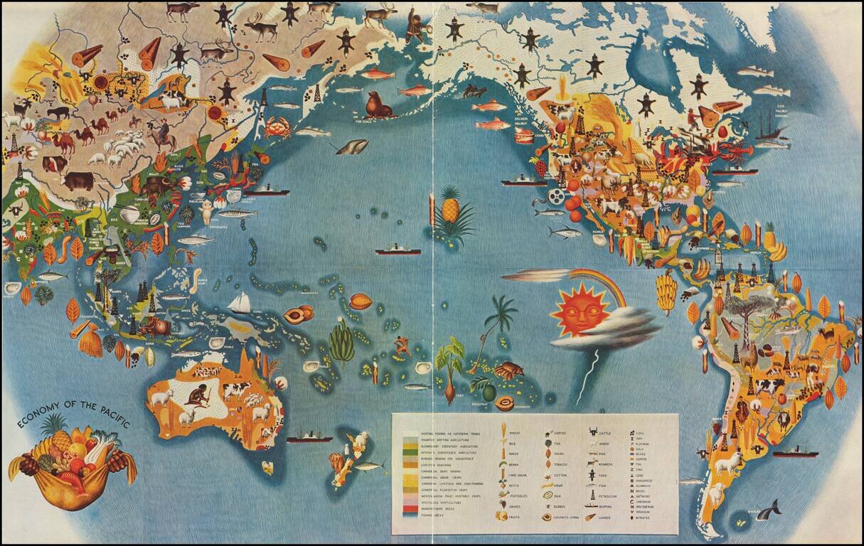
Smaller version of Miguel Covarrubias's iconic map from his Pageant of the Pacific series. This well regarded stylized map by the Mexican painter, illustrator, filmmaker and anthropologist Miguel Covarrubias, often called Mexico's Renaissance Man....
![[Musselini Celebrates Pearl Harbor] Grande Carta Del Pacifico](/map/small/64895.jpg)
Musselini Celebrates The Japanese Attack on Pearl Harbor -- Provoked by A Democratic Despot Issued 4 days after the Japanese attack on Pearl Harbor, this message from Musselini, celebrates the attack and speaking in fiery nationalistic rhetoric in...
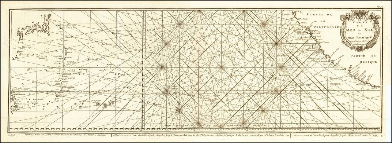
Impressive Chart of the Pacific Ocean Depicting a Thrilling Circumnavigation Dynamic chart of the mid-Pacific Ocean from the French-edition of Anson’s bestselling voyage account. It includes voyage tracks of Anson’s Centurion and the ship he...

Scarce late state of Guillaume De L'Isle's map of the Western Hemisphere, updated to include the 3 voyages of Captain James Cook. Dezauche also shows the route of the voyages of Abel Tasman (1642), Quiros, Magellan (1520), Le Maire (1616), Mendana...
![[Straits of Le Maire, Nova Guinea, South Pacific]](/map/small/61345op.jpg)
The Earliest Printed Map of Le Maire's Voyage Around Cape Horn and Across The Pacific Nice example of Joris van Spilbergen's rendering of Willem Schouten and Jacob Le Maire's map / sea chart of a portion of his circumnavigation of the world, showing...
Rare Golden Age Dutch Sea Chart of the Island of California and Western Pacific Rare Johannes Van Loon sea chart of the Western Pacific. The map appeared in the first edition of Van Loon's Zee Atlas. It derives from Doncker's map of the Western...
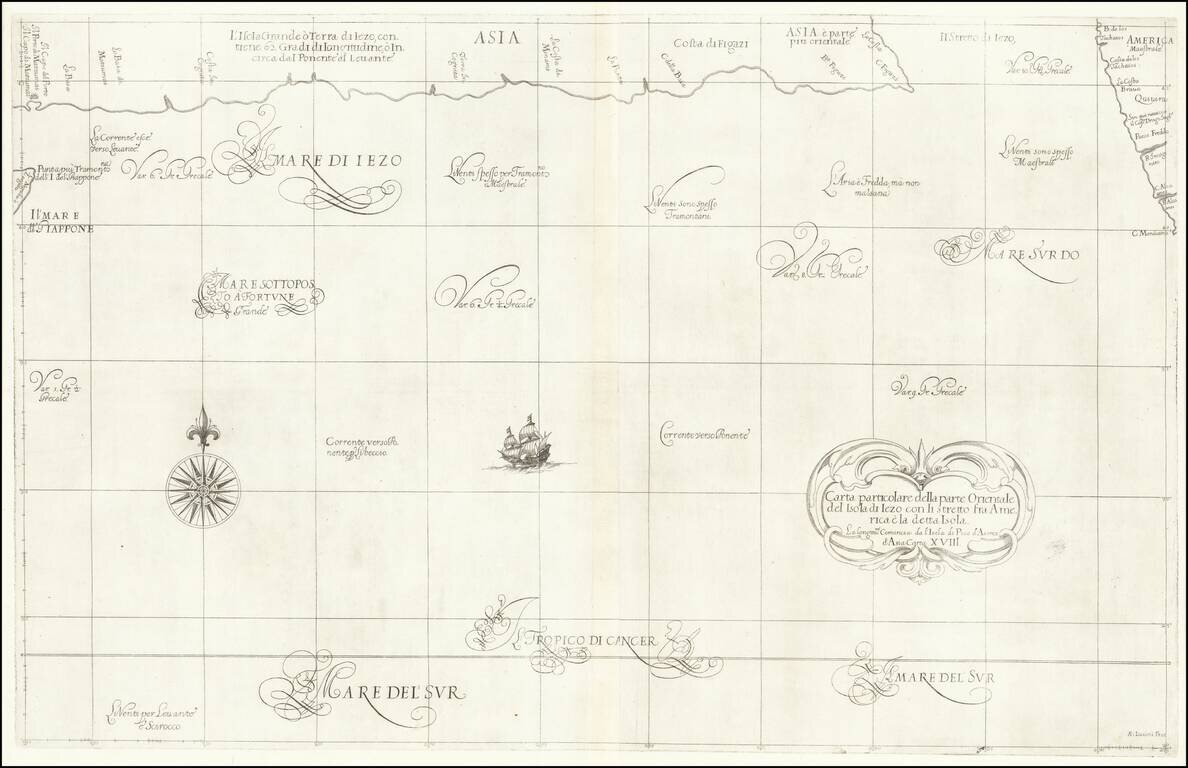
Fascinating map of the southern coast of Japan (Terra Iezo) and the Northwest Coast of America north of Cape Mendocino (including Quivira), from Dudley's Dell'Arcano del Mare. The map shows one of the great cartographic myths of the period, the...