Map size in jpg-format: 33.3871MiB
Click to open in high resolution (open in new tab).
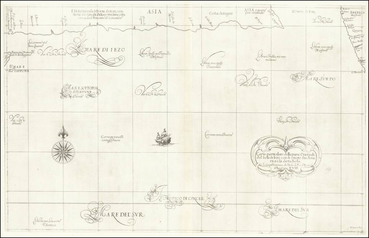
Fascinating map of the southern coast of Japan (Terra Iezo) and the Northwest Coast of America north of Cape Mendocino (including Quivira), from Dudley's Dell'Arcano del Mare.
The map shows one of the great cartographic myths of the period, the proximity of the Japanese coastline to America, separated only by a narrow "Stretto di Iezo" (Strait of Japan). The American Coastline shown on the map would be the source of a number of myths in future years, including the location of the lands discovered by the Chinese explorer Fou Sang and the Juan de Fuca's entrance to the Bay of the West.
This sea chart appeared in Robert Dudley's Dell'Arcano del Mare, one of the rarest and most highly sought after sea atlases of the 17th Century. Robert Dudley, an Englishman, produced this exquisite work while living in Florence. Dudley, who was believed to have received some of his information directly from Sir Francis Drake, labored for decades before finally releasing the first edition of this work when he was 73 years old. Dudley's atlas is of the utmost importance, being the first Sea Atlas published by an Englishman and the first Sea Atlas to treat the entire world (not just Europe). It is also the first atlas to utilize the Mercator Projection on a uniform basis and included significant advances in "Great Circle" navigation (shortest circle around the Globe). Its inclusion of winds and currents was also a monumental first. Completed in Manuscript form in 1636, it is among the most important works in the history of European Cartography.
Robert Dudley (1574 - 1649) was the illegitimate son of Robert Dudley, 1st Earl of Leicester. In 1594, Dudley led an expedition to the West Indies, of which he wrote an account. In 1605, he tried unsuccessfully to establish his legitimacy in court. After that he left England and converted to Catholicism, taking up residence in Florence where he served the Grand Dukes of Tuscany in their efforts to rid the Mediterranean of Piracy. There he worked as a noted shipbuilder and designed and published Dell'Arcano del Mare, the first maritime atlas to cover the whole world. He was also a skilled navigator, mathematician and engineer. In Italy, he styled himself Earl of Warwick and Leicester as well as Duke of Northumberland. He was a friend of Sir Francis Drake and relative of Thomas Cavendish, both of whom corresponded with Dudley and likely supplied some of the information for his Atlas.
If you are a student, write to us in telegram: @antiquemaps and indicate what material you need and for what work you need a map in high detail. We are ready to provide material on special terms. For students only!
![[First Map of the American Continent] Tavola dell' isole nuove, le quali son nominate occidentali, & indiane per diversi rispetti.](/map/small/67312.jpg)

![[Atlantis?] Ristretto Delle Carte presentate all' Academia delle Scienze di Parigi negli anni 1737 e 1752 dal Sig di Buache](/map/small/58667.jpg)