Lorenz (Laurent) Fries (ca. 1485-1532) was born in Mulhouse, Alsace. He studied medicine, apparently spending time at the universities of Pavia, Piacenza, Montpellier and Vienna. After completing his education, Fries worked as a physician in several places before settling in Strasbourg in about 1519. While in Strasbourg, Fries met the Strasbourg printer and publisher Johann Grüninger, an associate of the St. Dié group of scholars formed by, among others, Walter Lud, Matthias Ringmann and Martin Waldseemüller.
From 1520 to 1525, Fries worked with Grüninger as a cartographic editor, exploiting the corpus of material that Waldseemüller had created. Fries' first venture into mapmaking was in 1520, when he executed a reduction of Martin Waldseemüller's wall map of the world, first published in 1507. While it would appear that Fries was the editor of the map, credit is actually given in the title to Peter Apian. The map, Tipus Orbis Universalis Iuxta Ptolomei Cosmographi Traditionem Et Americ Vespucii Aliorque Lustrationes A Petro Apiano Leysnico Elucubrat. An.o Dni MDXX, was issued in Caius Julius Solinus' Enarrationes, edited by Camers, and published in Vienna in 1520.
Fries’ next project was a new edition of the Geographia of Claudius Ptolemy, which was published by Johann Grüninger in 1522. Fries evidently edited the maps, in most cases simply producing a reduction of the equivalent map from Waldseemüller's 1513 edition of the Geographie Opus Novissima, printed by Johann Schott. Fries also prepared three new maps for the Geographia, of Southeast Asia and the East Indies, China, and the world, but the geography of these derives from Waldseemüller's world map of 1507.
The 1522 edition of Fries' work is very rare, suggesting that the work was not commercially successful. In 1525, an improved edition was issued, with a re-edit of the text by Willibald Pirkheimer, from the notes of Regiomontanus (Johannes Müller von Königsberg).
After Grüninger's death in ca. 1531, the business was continued by his son Christoph, who seems to have sold the materials for the Ptolemy to two Lyon publishers, the brothers Melchior and Gaspar Trechsel, who published a joint edition in 1535, before Gaspar Trechsel published an edition in his own right in 1541.
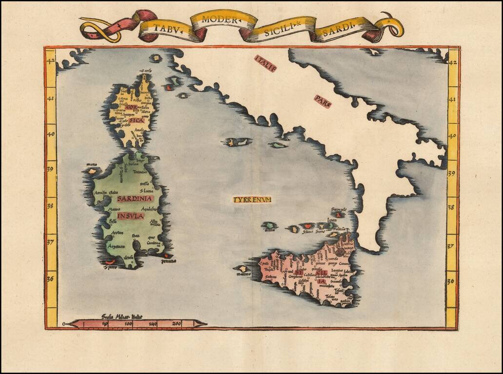
Nice example of the 1535 edition of Lorenz Fries modern map of Sicily and Sardinia. First published in Strasbourg by Johannes Gruninger in 1522, Fries map is based upon Waldseemuller's map of 1513.
![[Untited Modern Map of Cyprus, Syria, Palestine, etc.]](/map/small/55764.jpg)
One of the earliest obtainable modern maps of Cyprus, Syria, the Holy Land, and contiguous regions, from the 1525 edition of Fries edition of Ptolemy's Geographia. Fries map of Cyprus, Syria, Mesopotamia, Babylonia, Arabia Petraea, Armenia Minor and...
Finely colored example of Lorenz Fries map of China, Japan and adjoining regions, the first printed map to focus on China. Fries map of eastern Asia is the first European map to focus on the region of Japan and China alone . This map derives from...
![Tabula VIII Asiae [Central Asia] (Title on Verso)](/map/small/31320.jpg)
Gorgeous Ptolemaic map of Central Asia and Tartary and Western China, from Lorenz Fries' edition of Ptolemy's Geographia. This map is largely based on the 1513 map by Waldseemuller. Lorenz (Laurent) Fries was born in Alsace in about 1490. He studied...
![Tabula XII. Asiae [Title on verso] (Sri Lanka)](/map/small/55866.jpg)
Important early modern map of Taprobana, from Fries's 1525 edition of Geographia. This is an early woodblock map of the island of Taprobana, which depicts the typical misconceptions of Ptolemy showing the island greatly enlarged, surrounded by...
![Tabula IX Asiae [Pakistan & India] (Title on Verso)](/map/small/49098.jpg)
Gorgeous Ptolemaic map of Pakistan and Western India, from Lorenz Fries' edition of Ptolemy's Geographia. This map is largely based on the 1513 map by Waldseemuller.
![[Southeast Asia]](/map/small/59685op.jpg)
One of Ptolemy's Greatest Errors An important early map of the Indian Ocean and Southeast Asia, drawn from Ptolemy's Geography. The map illustrates one of the greatest of the Ptolemy errors, the belief that a southern continent existed, which...
![[Southeast Asia] Tabu. Mo. In. Orig. (First Modern Map of Southeast Asia -- Old Color)](/map/small/41330.jpg)
Old color gold heightened (on verso) example of the rare 1522 edition of the first printed map to focus on the Southeast Asian islands and indeed, the only map to focus on this area in the first half of the 16th Century. Fries map was a significant...
Early Antique Map of Southeast Asia Finely colored example of the first printed map to focus on Southeast Asia and the only map to focus on this area in the first half of the 16th century. Fries' map was a significant milestone in the Mapping of...
![[Armenia and Caspian Region] Tabula III Asiae](/map/small/50935.jpg)
Marvelous map of Armenia and the regions between the Black Sea, Caspian Sea and the Caucus Mountains. Lorenz (Laurent) Fries was born in Alsace in about 1490. He studied medicine, apparently spending time at the universities of Pavia, Piacenza,...
Rare 1525 Map of the Arabian Peninsula and Environs. Nice example of the 1525 edition of Lorenz Fries map of the Arabian Peninsula, Sinus Persicus and adjoining regions. Important early map of the Middle East, from the 1535 edition of Lorenz Fries'...
![Tabula VIII Asiae [Central Asia] (Title on Verso)](/map/small/50940.jpg)
Gorgeous Ptolemaic map of Central Asia and Tartary and Western China, from Lorenz Fries' edition of Ptolemy's Geographia. This map is largely based on the 1513 map by Waldseemuller.
![[Arabia] Tabula Sexta Asiae (Title on Verso)](/map/small/46799.jpg)
Nice example of the 1535 edition of Lorenz Fries' map of the Arabian Peninsula, Persian Gulf and adjoining regions. Important early map of the Middle East, from the 1535 edition of Lorenz Fries' Geographia, based upon the works of Claudius Ptolemy....
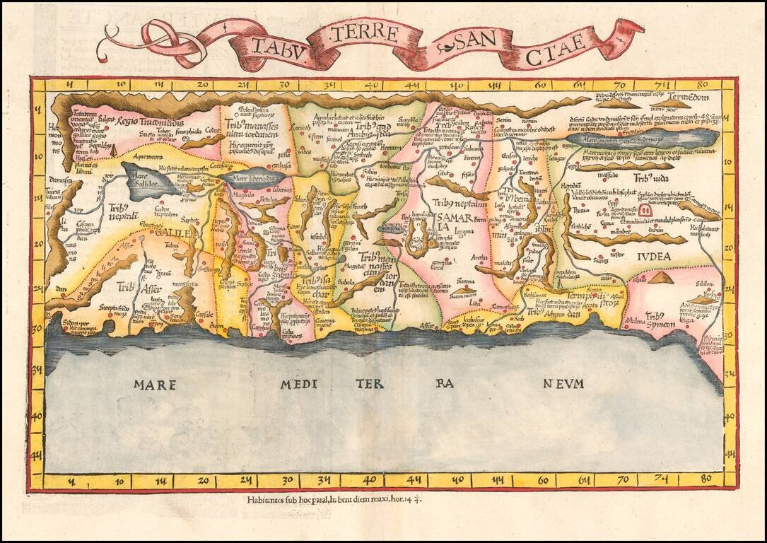
Rare early state of Fries's edition of the landmark Sanuto-Vesconte map, the most influential modern map of the Holy Land published in the 15th Century. As noted by Nebenzahl, the Sanuto-Vesconte map " was destined to provide the basic image of the...
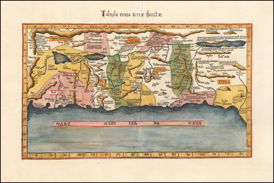
An Early Modern Map of the Holy Land Finely colored example of Fries's edition of the landmark Sanuto-Vesconte map, the most influential modern map of the Holy Land published 15th Century. As noted by Nebenzahl, the Sanuto-Vesconte map " was destined...
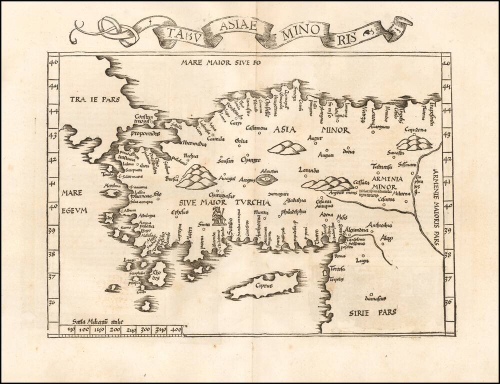
Rare early state of Fries map of Asia Minor and Cyprus, based upon the work of Claudius Ptolemy. Latin text and elaborate decorations on the verso.