Map size in jpg-format: 15.489MiB
Click to open in high resolution (open in new tab).
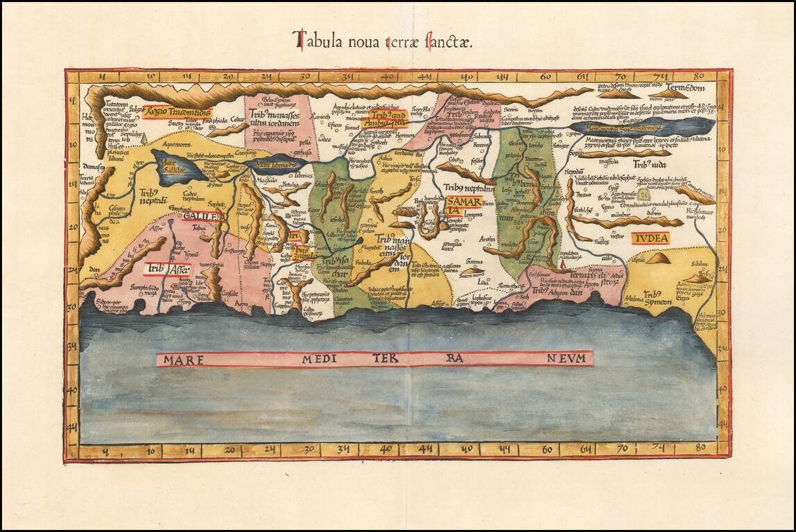
An Early Modern Map of the Holy Land
Finely colored example of Fries's edition of the landmark Sanuto-Vesconte map, the most influential modern map of the Holy Land published 15th Century.
As noted by Nebenzahl, the Sanuto-Vesconte map " was destined to provide the basic image of the Holy Land until the eighteenth century." When first published in 1482 in both the Ulm and Berlinghieri (Florence) editions of Ptolemy, the map was the first printed map of the Holy Land based on modern sources.
Fries map, which is based upon Waldseemuller's interpretation of the map which was first published in 1513, is the first example of this projection which is reasonably obtainable for most collectors. The map was published with small changes to the title and verso in 1522, 1525, 1535 and 1541. The first two editions are very rare on the market, this being the first example we have ever offered.
Pietro Vesconte was an early 14th Century Genoese cartographer and geographer. A pioneer in the field of the portolan charts, he influenced Italian and Catalan mapmaking throughout the fourteenth and fifteenth centuries. He appears to have been the first professional mapmaker to sign and date his works regularly. Vesconte's nautical charts are among the earliest to map the Mediterraean and Black Sea regions accurately. Vesconte provided a world map, nautical atlas, a map of the Holy Land and plan of Acre and Jerusalem for inclusion in Marino Sanuto's Liber secretorum fidelium cruces, a work which aimed to encourage a new crusade. There are three known copies of Sanuto's Liber which that include Vesconte's maps.
Marino Sanuto (c. 1260 - 1338) was a Venetian statesman and geographer, who is best known for his life-long attempts to revive crusades. His Liber secretorum fidelium cruces, also called Historia Hierosolymitana, Liber de expeditione Terrae Sanctae, and Opus Terrae Sanctae, included an extensive discussion of trade and trade-routes, as well as of political and other history and included a number of maps and maps and plans which would become important in the development of cartography 15th and 16th Century cartography. His work was begun in March 1306, and first finished in January 1307, when it was offered to Pope Clement V as a manual for true Crusaders who desired the reconquest of the Holy Land. To this original Liber Secretorum Sanuto it added largely; two other "books" composed between December 1312 and September 1321, when the entire work was presented by the author to Pope John XXII, together with a map of the world, a map of modern Palestine, a chart of the Mediterranean, the Black Sea and west European coasts, and plans of Jerusalem, Antioch and Acre. A copy was also offered to the king of France, to whom Sanuto desired to commit the military and political leadership of the new crusade.
If you are a student, write to us in telegram: @antiquemaps and indicate what material you need and for what work you need a map in high detail. We are ready to provide material on special terms. For students only!


![[Early Montanus World Map in Volume Eight of the Plantin Polyglot Bible]](/map/small/53766.jpg)