logo

1593. Zelandia inferioris Germaniae pars magno circumdata Oceano plurimis insulis est disterminata. Terra est urbi admodum gleba, populosa et ob portuum commoditatem navigatione celebris. Habet autem pre ceteris tres insulas Valachriam Scaldian et Suiidbeueland

  • Zelandia inferioris Germaniae pars magno circumdata Oceano plurimis insulis est disterminata. Terra est urbi admodum gleba, populosa et ob portuum commoditatem navigatione celebris. Habet autem pre ceteris tres insulas Valachriam Scaldian et Suiidbeueland

Zelandia inferioris Germaniae pars magno circumdata Oceano plurimis insulis est disterminata. Terra est urbi admodum gleba, populosa et ob portuum commoditatem navigatione celebris. Habet autem pre ceteris tres insulas Valachriam Scaldian et Suiidbeueland information:

Year of creation: 
Resolution size (pixels): 
 12308x9315 px
Disk Size: 
 24.9994MiB
Number of pages: 
 1
Place: 
 Antwerp
Author: 

Print information. Print size (Width x height in inches):
Printing at 72 dpi 
  170.94 х 129.38
Printing at 150 dpi 
 82.05 х 62.1
Printing at 300 dpi 
 41.03 х 31.05

An example of detailing the file of this map of in a printable high-resolution:

Click to open in high resolution (open in new tab).
Attention! this is just the central piece (central area 960x960 px) of the map file!
This is an example, so that you can see and study the level of detail of a given map. The entire Map will be fully available after payment!

Zelandia inferioris Germaniae pars magno circumdata Oceano plurimis insulis est disterminata. Terra est urbi admodum gleba, populosa et ob portuum commoditatem navigatione celebris. Habet autem pre ceteris tres insulas Valachriam Scaldian et Suiidbeueland

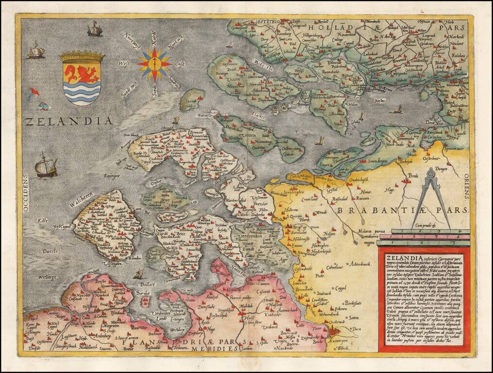
Rare early map of Zeeland, published by De Jode and engraved by Jan Van Doetecum.

One of the earliest separate maps of Zeeland published in the Low Countries.

Gerard De Jode (1509-1591) was a pre-eminent mapmaker in the late seventeenth century, a time when the Dutch dominated the map trade. He was known for his many maps, some of which featured in Speculum Orbis Terrae (first edition Antwerp: 1578). Although never as successful as Ortelius’ Theatrum, the Speculum did get republished in a second edition in 1593, two years after De Jode’s death, by Arnold Coninx, and included this map. After his death, Gerard’s son, Cornelis (1568-1600), and his wife, Paschina, ran the shop. Unfortunately, Cornelis died young in 1600, aged only 32, and the stock and plates were sold to the publisher Joan Baptista Vrients.  


Special conditions for students!

If you are a student, write to us in telegram: @antiquemaps and indicate what material you need and for what work you need a map in high detail. We are ready to provide material on special terms. For students only!

Item information:

Year of creation:
Size:
12308x9315 px
Disk:
24.9994MiB
Number of pages:
1
Place:
Antwerp
Author:
Gerard de Jode.
$14.99

Related item