Map size in jpg-format: 42.1981MiB
Click to open in high resolution (open in new tab).
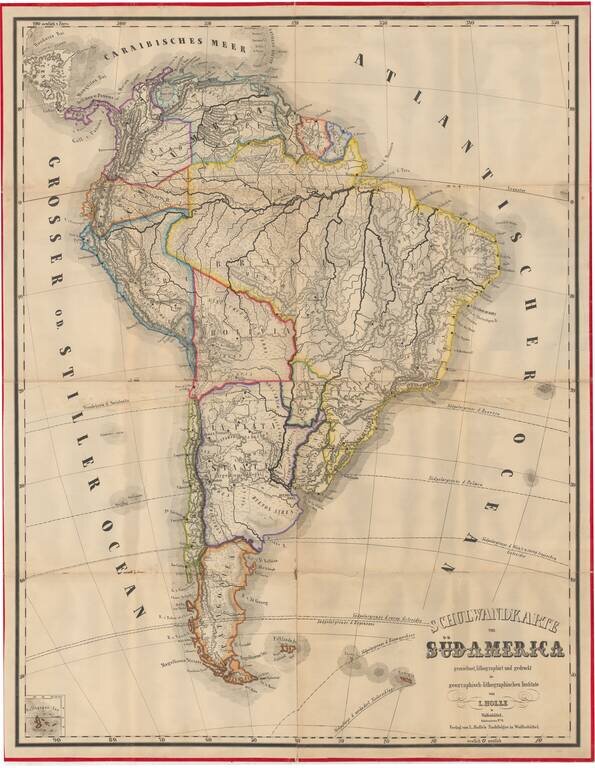
Very rare (unrecorded) wall map of South America, published by Leinhert Holle in Wolfenbuttel.
The Geographisch-lithographisches Institut was an active publisher of maps in the mid-19th Century and thereafter. During a brief burst of activity in the early 1850s, the firm published a number of fascinating American maps, which was timed to the visit of Karl Wilhelm Pressler, who had been working for the Texas General Land Office, and made a brief return to his native Germany (Wolfenbuttel) to pick up his bride, before returning to Texas. It was during this time that Holle published 2 very rare American maps, one of Texas, based on information received from Pressler, and one of the United States, both of which were issued separately in pocket map format with printed boards.
Holle's Texas map is especially interesting, since it pre-dates Pressler's GLO map of Texas. This was also a period where there was a tremendous amount of emigration from Germany to the Western United States, with the Wolfenbuttel publisher producing several of the best guide books of the period, and almost certainly creating a burst of interest in North America for educational purposes.
If you are a student, write to us in telegram: @antiquemaps and indicate what material you need and for what work you need a map in high detail. We are ready to provide material on special terms. For students only!


![[Signed Political Satire Artwork] Vietnam ... Vietnam ... Vietnam ...](/map/small/68726.jpg)