Map size in jpg-format: 41.7894MiB
Click to open in high resolution (open in new tab).

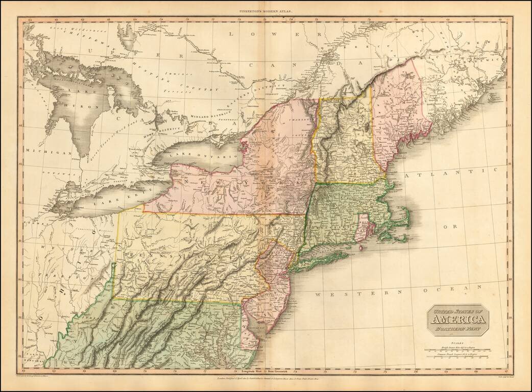
Fine large format map of the Northeast, at the end of the War of 1812, published by Pinkerton.
Large detailed map of the Northeastern United States, from the District of Main to Michigan, Ohio, Virginia and Delaware, including most of the Upper Chesapeake and the Washington DC area.
This example of the map reflects a number of errors in the outline coloring of the states, including a complete miss on New Hampshire and Vermont, a big miss on the northern New York State Boundary with Canada, and southern boundary (placing Manhattan in New Jersey), missed boundaries for Connecticut, Rhode Island and Massachusetts, inaccurate depiction of the northwestern corner of Virginia and a complete miss on the Delaware-Maryland Boundary.
Highly detailed map, with one of the earliest appearances of Michigan Territory. Many early forts still appear in Ohio, Michigan and the Western part of Pennsylvania and Virginia. Indiana appears south of the Ohio River in Virginia, near Vienna. Ohio is also named Western Territory. The Maine-Canada Boundary disputes are still not resolved. The map names early counties, towns, Indians, etc.
Pinkerton's maps are highly detailed and larger format than contemporary maps by Cary and Thomson, and are prized for their precision and detail.
John Pinkerton (1758-1826) was Scottish literary critic, historian, poet, and geographer. From age twelve he educated himself at home in Edinburgh, as his father had declined to send him to university. His father instead apprenticed John to a lawyer, William Aytoun, but the boy did not like the legal profession. In his spare time, the young man wrote poetry and collected Scottish ballads, which he tried to have published. After the death of his father, Pinkerton moved to London in 1781, to be closer to the vibrant literary scene.
Pinkerton’s earliest publications were collections of ballads. However, a fellow critic uncovered that Pinkerton had forged several of the “ancient” poems and published accusations against Pinkerton in the Gentleman’s Magazine. Throughout the 1780s, Pinkerton published poetry, works on numismatics, and historical works. He corresponded with Sir Walter Scott, Horace Walpole, and Edward Gibbon, but most of his friendships ended in acrimony. Pinkerton was a hypochondriac, unorthodox about morality and religion, and a prickly personality who lived with several women during his lifetime, marrying illegally at least once.
After 1800, Pinkerton turned to geographical works. In 1802 he published Modern Geography, a text that was quite popular and translated into French and Italian. In 1808-15, he produced a New Modern Atlas, which was well received, followed by A General Collection of Voyages and Travels (1808-14). Soon after these projects, Pinkerton moved to Paris, where he lived until he died in 1826.
If you are a student, write to us in telegram: @antiquemaps and indicate what material you need and for what work you need a map in high detail. We are ready to provide material on special terms. For students only!
![[The First Maps in a la poupée Printed Color] Cartes en Couleur des Lieux Sujets aux tremblements de Terre Dans toutes les parties du Monde Selon le Sisteme de l’impulsion Solaire](/map/small/52293op.jpg)

