logo

1940. United States Air Mail Service Post Office Department.

  • United States Air Mail Service Post Office Department.

United States Air Mail Service Post Office Department. information:

Year of creation: 
Resolution size (pixels): 
 18304x12078 px
Disk Size: 
 46.9769MiB
Number of pages: 
 1
Place: 
 Washington, D.C.

Print information. Print size (Width x height in inches):
Printing at 72 dpi 
  254.22 х 167.75
Printing at 150 dpi 
 122.03 х 80.52
Printing at 300 dpi 
 61.01 х 40.26

An example of detailing the file of this map of in a printable high-resolution:

Click to open in high resolution (open in new tab).
Attention! this is just the central piece (central area 960x960 px) of the map file!
This is an example, so that you can see and study the level of detail of a given map. The entire Map will be fully available after payment!

United States Air Mail Service Post Office Department.

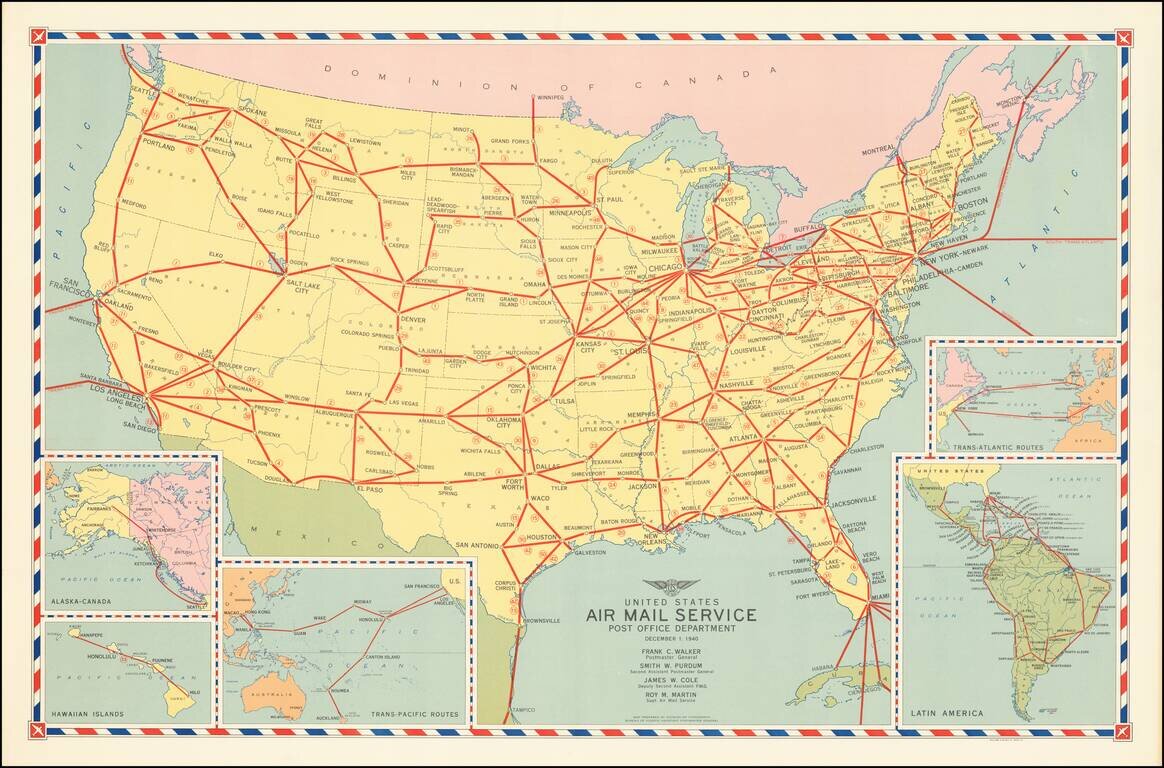
America's Air Mail Routes in the Year Before it Entered World War II.

Attractive vintage map of airmail service relevant to the United States, in December of 1940.

The map includes the following insets:

  • Alaska-Canada
  • Hawaiian Islands
  • Trans-Pacific Routes
  • Trans-Atlantic Routes
  • Latin America.

Periodic Updates

The first similar air mail map which we could identify was issued in 1938, under the title: "Domestic air mail service in the United States."

Rumsey notes a March 1, 1939 map entitled "Domestic & Foreign Air Mail Service United States Post Office Department," which seems to be the pre-cursor to this 1940 map. There are significantly more routes on the present map.

The Rumsey collection includes an edition of this map dated December 19, 1941, which includes additional routes and stops, including:

  • Great Falls, Montana to Cut Bank Shelby to Lethbridge.
  • Salem, Oregon and Medford Oregon
  • Springfield, Illinois to Bloomington, Illinois, to Chicago.
  • Chicago to Muskegon, Michigan
  • South Bend-Mishawaka, Indiana to Toledo, Ohio
  • Toledo to Akron, Ohio
  • Pittsburg to Wheeling WV to Charleston-Dunbar, WV
  • Charleston-Dunbar to Johnson City-Kingport Bristol, Tennessee
  • Evansville, Indiana to Louisville
  • Cincinnati to Lexington, Kentucky to Knoxville, Tennessee
  • Chattanooga, Tennesee to Knoxville
  • Montgomery, Alabama to Columbus, Georgia
  • Birmingham, Alabama to Chattanooga, Tennesee
  • Shreveport, Louisiana to Pine Bluff, Arkansas to Memphis, Tennesssee.
  • Charlotte, NC to Roanoke, Virginia
  • Charlotte to Winston Salem, NC to Richmond, Virginia
  • Houston, Texas to Shreveport
  • Bangor, Maine to Moncton-Shediac Nova Scotia.
  • Buffalo to Toronto
  • Niagara Falls to Windsor
  • Philadelphia to Cleveland
  • Philadelphia to Reading, Pennsylvania
  • Atlantic City, New Jersey to Baltimore
  • Atlantic City to New York
  • Atlantic City ot Philadelphia
  • Bermuda to Horta (Azores)
  • Bermuda to South America
  • Manila to Singapore

As well as the removal of certain routes, including:

  • Joplin, Missouri

Rarity

The present example is dated December 1, 1940 and is extremely rare. We were unable to locate any other examples of the map, other than the examples we acquired from the Lloyd Welch Pogue collection (see below).

Provenance

Lloyd Welch Pogue (October 21, 1899 – May 10, 2003) American aviation lawyer and chairman of the Civil Aeronautics Board. Pogue, a native of Grant, Iowa, was instrumental in forming the policy structure that led civil aviation through World War II and into the booming Post-War Period. He was appointed Chairman of the CAB by President Franklin Delano Roosevelt, and he served as Chairman until 1946. During his tenure Pogue helped strike down a plan for a single world airline.


Special conditions for students!

If you are a student, write to us in telegram: @antiquemaps and indicate what material you need and for what work you need a map in high detail. We are ready to provide material on special terms. For students only!

Item information:

Year of creation:
Size:
18304x12078 px
Disk:
46.9769MiB
Number of pages:
1
Place:
Washington, D.C.
Author:
Division of Topography, Postmaster General.
$14.99

Related item