Map size in jpg-format: 32.6804MiB
Click to open in high resolution (open in new tab).
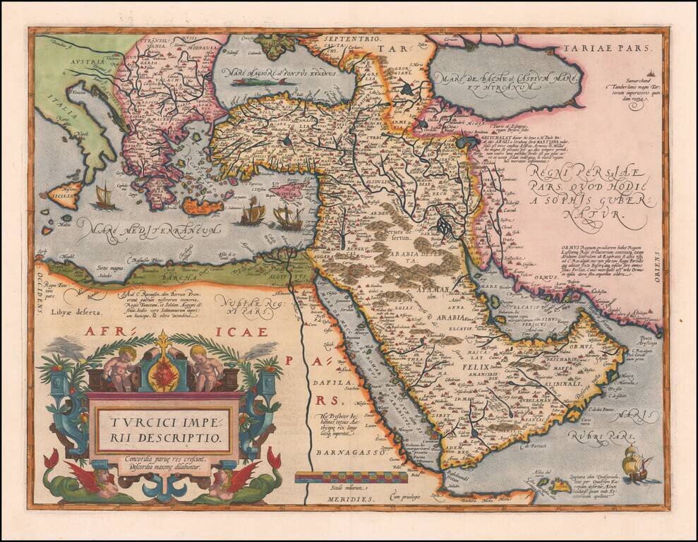
Second Edition of the Ortelius Map of the Turkish Empire
Nice example of Ortelius' Turkish Empire, embracing the Middle East, Turkey and the Eastern Mediterranean from Sicily to Cyprus.
The map is based upon Giacomo Gastaldi's wall map of Asia of 1561. It includes an ornate cartouche in the lower left corner decorated with lattice work, lanterns, and two female centaurs. The inscription below the title reads, "Through unity small things grow, through discord they fall asunder." This was likely a reference to the power of the diverse Ottoman Empire in the later sixteenth century, as the Empire was reaching its zenith at precisely the time this map was published. Other decorations include four sailing vessels and a sea monster in the Black Sea.
There are several other descriptions of note on the map. One paragraph, near Lake Actamar just below the Caspian Sea, describes the various names for the lake throughout history. It also mentions that the dried fish caught there are sold around the region. Resources and goods are important to Ortelius with regard to the Ottoman Empire, as he also mentions the famous market town of Ormus, capital of a tributary kingdom that answers to Lusitania. Near Jemen he mentions that the local incense is distributed around the world, while the aloe of Zocotara is also singled out for praise. Finally, of note because it was representative of the popularity of the myth, near the Nile is the inscription, "Here rules Prester John far and wide, king of all of Æthiopia."
Ortelius' map of the Turkish Empire shows the might of this large political entity. Under the reign of Sultan Selim I (r. 1512-1520), the empire trebled in size. Suleiman I, also known as Suleiman the Magnificent, was the tenth and longest ruling Sultan, maintaining power from 1520 until his death in 1566. Under his policies, the Empire extended further to conquer Belgrade, Rhodes, and much of Hungary and Iraq. Suleiman I was a well-known political figure of the sixteenth century and his power radiates from the territory highlighted on this map. The Ottoman Empire would continue to expand and flourish in the seventeenth century, a constant foil to the other European empires.
The influence of this and other Ortelius maps stems from the popularity and dominance of his atlas in the European market. In 1570, Ortelius published the first modern atlas; that is, a set of uniform maps with supporting text gathered in book form. Previously, there were other bound map collections, specifically the Italian Lafreri atlases, but these were sets of maps-not necessarily uniform-selected and bound together on demand.
Theatrum Orbis Terrarum, Ortelius' atlas, outperformed competing atlases from other cartographic luminaries like the Mercator family. Between 1570 and 1612, 31 editions of the atlas were published in seven languages.
Ortelius included the first edition of this map in the first edition of his atlas in 1570. The first edition plate was used until 1579, when a second plate with a different cartouche was substituted for the first version.
The cartographic features of the two are the same.
If you are a student, write to us in telegram: @antiquemaps and indicate what material you need and for what work you need a map in high detail. We are ready to provide material on special terms. For students only!
![[Facsimile - 15th Century Portolan Sea Chart] Portolan des Iehuda ben Zara](/map/small/64285.jpg)