logo

1732. Topographica Repraesentatio Barbarici Portus et Urbis Munitae Oran una cum adjacente ora maritima, quae sita est in regno Telensin, ab Hispanis jam primum Anno . et prosteaquam Anno MDCCVIII. Mavris. reipublicae nimirum Algiericae rursus cesfit, hoc Anno

  • Topographica Repraesentatio Barbarici Portus et Urbis Munitae Oran una cum adjacente ora maritima, quae sita est in regno Telensin, ab Hispanis jam primum Anno . et prosteaquam Anno MDCCVIII. Mavris. reipublicae nimirum Algiericae rursus cesfit, hoc Anno

Topographica Repraesentatio Barbarici Portus et Urbis Munitae Oran una cum adjacente ora maritima, quae sita est in regno Telensin, ab Hispanis jam primum Anno . et prosteaquam Anno MDCCVIII. Mavris. reipublicae nimirum Algiericae rursus cesfit, hoc Anno information:

Year of creation: 
Resolution size (pixels): 
 14352x12350 px
Disk Size: 
 55.5444MiB
Number of pages: 
 1
Place: 
 Nuremberg
Author: 

Print information. Print size (Width x height in inches):
Printing at 72 dpi 
  199.33 х 171.53
Printing at 150 dpi 
 95.68 х 82.33
Printing at 300 dpi 
 47.84 х 41.17

An example of detailing the file of this map of in a printable high-resolution:

Click to open in high resolution (open in new tab).
Attention! this is just the central piece (central area 960x960 px) of the map file!
This is an example, so that you can see and study the level of detail of a given map. The entire Map will be fully available after payment!

Topographica Repraesentatio Barbarici Portus et Urbis Munitae Oran una cum adjacente ora maritima, quae sita est in regno Telensin, ab Hispanis jam primum Anno . et prosteaquam Anno MDCCVIII. Mavris. reipublicae nimirum Algiericae rursus cesfit, hoc Anno

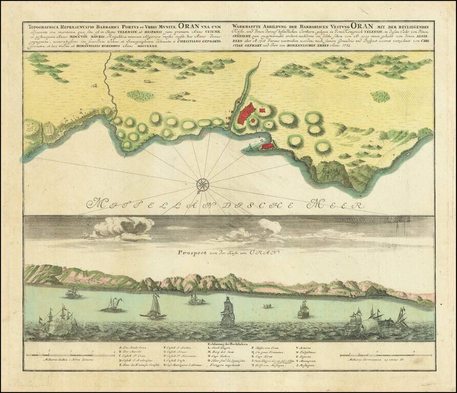
Scarce antique engraved view and plan of Oran, in Algeria, by the German mapmakers Homann Heirs, published in Nuremberg in 1732.

In the view at the bottom, there are xebecs and other sailing vessels, including some firing on one another, possibly indicative of the piracy for which the region was famous during most of its early history.

The view has a 24-point key that names buildings and landmarks of the city.

In 1732, Oran had been recaptured by the Spanish from the Ottoman Empire, which in turn had taken the city in 1708.

Homann Heirs was a German publishing firm that enjoyed a major place in the European map market throughout the eighteenth century. Founded in 1702 by Johann Baptist Homann, the business passed to his son, Christoph, upon Johann’s death in 1724. Christoph died in 1730, aged only 27, and the firm was inherited by subsequent Homann heirs. This altered the name of the company, which was known as Homann Erben, or Homann heirs. The firm continued in business until 1848.


Special conditions for students!

If you are a student, write to us in telegram: @antiquemaps and indicate what material you need and for what work you need a map in high detail. We are ready to provide material on special terms. For students only!

Item information:

Year of creation:
Size:
14352x12350 px
Disk:
55.5444MiB
Number of pages:
1
Place:
Nuremberg
Author:
Homann Heirs.
$14.99

Related item