
Map size in jpg-format: 52.4057MiB
Click to open in high resolution (open in new tab).

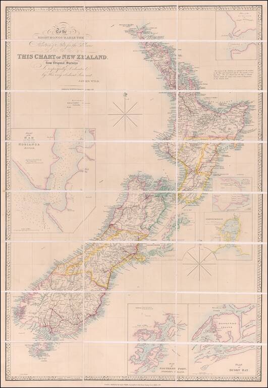
Previously Unrecorded, Late State of the Best General Map of New Zealand then Extant
Important, previously-unrecorded state of the famous McDonnell-Wyld map of New Zealand, published by James Wyld Jr. in London in ca. 1885.
This seems to be the latest surviving state we could locate, based upon the completion of certain railroad lines in the North Island (see below).
Brian Hooker, in his longitudinal study of Wyld's iconic map, identifies 27 states of the map, noting that, "As a series, they graphically illustrate the vast changes that were occurring throughout this country between 1834 and the 1860s.” Since the publication of Hooker’s article, states have been identified dating up to 1879.
The map shows the entirety of the archipelago, along with seven insets: Plan of the Entrance to Port Manoukao - Plan of Victoria Bay of Islands - Port Nicholson - Oyerri or Pelorus River - Plan of Dusky Bay - Plan of Southern Port, Stewarts Island - Plan of the Bar and Part of the Hokianga River.
The map shows a variety of topographic detail including riverine systems, mountains and volcanoes (with heights in many cases), and towns and villages. As the key under the title indicates, an important part of this map are the roads and railways; the latter are differentiated by those railways that have been completed and those that are under construction.
In the top left corner is a title cartouche adorned with elegant script. The cartouche also carries a dedication to the Secretary of State for the Colonies, a position (re) created in 1854 to manage relations with Britain’s colonies worldwide. New Zealand remained a British colony from 1841 to 1907.
The map is dissected and presented with a handsome slip case with Wyld’s business placard affixed to it.
Dating the map
The present map would seem to date to no earlier than 1885 and no later than 1887, based upon an examination of the completed railways and railways under construction in the North Island. These include the fully completed Marton-New Plymouth Line (completed in 1885) and the partially completed Palmerston North–Gisborne Line (constructed between 1872 and 1891). Most notably, the map shows the PN-GL line from Napier to the south as being completed to Matamau (June 23, 1884), Dannevirke (December 1, 1884), and a bit further south to Tahoraite (Tahoraiti), but not yet reaching Woodville at the north end of the Manawatu Gorge (March 22, 1887).
We note a number of other railroad details throughout the map which seem to be more advanced than other extant states we have located, indicating that this is the oldest extant state.
The history of the McDonnell-Wyld Map
The McDonnell-Wyld Map, first published in 1834, is one of the most important and influential early maps of New Zealand. Between 1834 and 1870, the map was issued in at least 27 different states, showing the evolution of New Zealand's early exploration and settlement.
The map received glowing reviews in the New Zealand Journal (London). The June 20, 1840 issue describes it as: "the best general map of New Zealand extant." In the November 12, 1840 issue, a review of the third edition gushes, “This edition is executed with Mr Wyld's usual care. No pains have been spared to collect the best information.”
While Wyld published the map, the original draft was compiled by Lieutenant Thomas McDonnell, a trader active in New Zealand in its early years of British occupancy. After a career in the Royal Navy, McDonnell began working with the East India Company from 1815. By 1831, he was living in Horeke, along the Hokianga River. Researchers like J. O’C. Ross suggest that McDonnell journeyed to England in 1834 with his map already completed; once in London, he persuaded James Wyld the Elder to publish it.
However, Hooker argues that this is likely a specious story. It is more likely that McDonnell came to England in early 1834 where he was likely prevailed upon by Wyld to compile the chart. McDonnell used sources available to him in London, including Dumont d’Urville’s 1833 atlas. Other sources included the observations and surveys of James Cook, George Vancouver, Antoine Raymond d’Entrecasteaux, William Stewart and S. Chase (Pegasus, 1809), and Louis Isadore Duperrey.
Wyld was indeed a savvy business man. He knew that the only previous single-sheet chart to show the archipelago was an unnumbered Admiralty chart of 1816 (later chart 1212), which was based on James Cook’s earlier chart of 1773. By the early 1830s, demand was considerable for a more updated chart. Missionaries were the initial British settlers in New Zealand; Samuel Marsden, one of the original missionaries of the Church Missionary Society, gave the first sermon in New Zealand on Christmas Day 1814. Colonists eager for land and opportunity began to trickle in, including the trader McDonnell.
This was therefore the second single-sheet map of New Zealand available. It set the example for several future maps, including the Admiralty general chart of 1838. It also stayed popular as New Zealand continued to be a desirable destination for British immigrants. Formal colonization began in 1837 and by 1840 there were roughly 2,000 Europeans living in New Zealand, the majority single men—whalers, traders, and missionaries—and 7 of 10 of them were of British descent. The non-Māori population in 1880 was over 500,000.
Rarity
The present example of the map would seem to be the only extant example published in the 1880s.
While pre-1870 examples of the map are not particularly rare, the states of the map dating to after 1870 are apparently extremely rare. We were not able to locate any examples of a post-1870 map offered for sale at auction or in a dealer catalog in any database.
OCLC locates the following late states:
If you are a student, write to us in telegram: @antiquemaps and indicate what material you need and for what work you need a map in high detail. We are ready to provide material on special terms. For students only!

![Pascaart vertoonende de zeecusten van Chili, Peru, Hispania Nova, Nova Granada, en California…. [Early New Zealand Inset]](/map/small/65168.jpg)