Map size in jpg-format: 21.9289MiB
Click to open in high resolution (open in new tab).
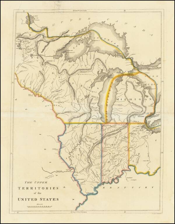
An Early American Map of the Old Northwest
Nice example of the rare 1814 edition of Mathew Carey's map of the old Northwest.
The map reflects a very early appearance of Michigan Territory (organized 1805), which had not yet appeared separately on any map. The Upper Peninsula is still not part of Michigan Territory.
The appearance of Illinois (organized in 1809) and Indiana (organized 1800), are among the earliest on a printed map. Illinois is pushed considerably west of its true location. Chicago is part of the Northwest Territory above Illinois, and noted as US Land, a vestige of its acquisition in the Treaty of Grenville. There are settlements along the Mississippi, but none in the interior of Illinois.
Indiana includes some settlements, most notably the Fort Wayne and Ouatinon lands, again first acquired as part of the Treaty of Grenville. Ft. S. Clare is shown on Lake Huron, along with Detroit. Ohio is similarly sparsely populated. An important map of the region.
Carey published his American Atlas in 1795, which became the first folio atlas published in America. He later issued General Atlases in 1796 and after. In 1814, he became the first American publisher to offer hand coloring.
If you are a student, write to us in telegram: @antiquemaps and indicate what material you need and for what work you need a map in high detail. We are ready to provide material on special terms. For students only!
![[The First Maps in a la poupée Printed Color] Cartes en Couleur des Lieux Sujets aux tremblements de Terre Dans toutes les parties du Monde Selon le Sisteme de l’impulsion Solaire](/map/small/52293op.jpg)