Map size in jpg-format: 130.139MiB
Click to open in high resolution (open in new tab).
"Remarkable for its Clarity of Execution and Detail" (Rumsey)
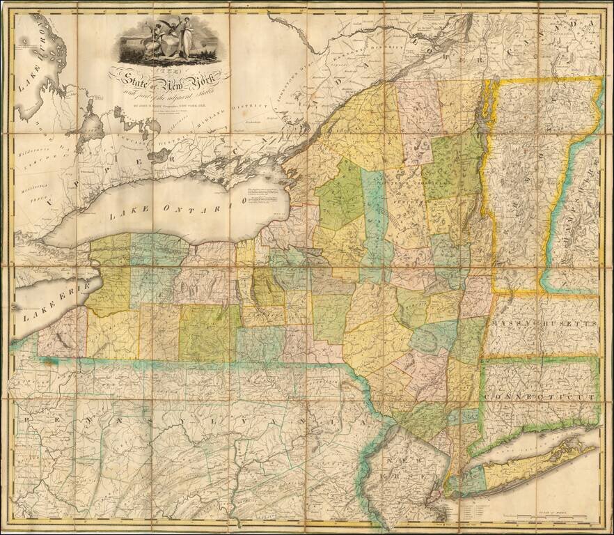
Fine example of John Eddy's large map of New York State, engraved by Peter Maverick.
Nice example of one of the most important maps of the state of New York issued in the first part of the 19th Century. Engraved by Tanner, Vallance, Kearny & Co. Philadelphia. Printed by Saml. Maverick N. York. New York. Published by James Eastburn & Co. at the Literary Rooms in Broadway.
The cartography of New York is shown in great detail, embellished with a finely engraved cartouche with the seal of the state, together with Vermont, and parts of Canada, New Hampshire, Connecticut, Pennsylvania, and New Jersey.
In 1811, John Eddy published a "Map of the Western Part of the State of New-York Showing the Route of the Proposed Canal from Lake Erie to Hudson's River," compiled at the request of the Canal Commissioners. In 1814, he published a map of the New York City environs. Shortly thereafter, he published a map of the Niagara River, and at this time Gov. DeWitt Clinton asked him to compile a map showing means of communication between the Great Lakes and the Atlantic via Lake Erie and the Hudson River.
In 1817, shortly before his death, Eddy finished compiling this large map of New York State, but died suddenly on December 22, 1817 at the age of 33. "The State of New York With Part of the Adjacent States" was published posthumously in 1818, and is considered one of the most beautiful and informative maps ever made of New York State and neighboring states.
If you are a student, write to us in telegram: @antiquemaps and indicate what material you need and for what work you need a map in high detail. We are ready to provide material on special terms. For students only!

![[Site of A Presidential Assassination] Plan of the Pan American Exposition to be held at Buffalo, New York (May 1 - Nov. 1, 1901)](/map/small/69181.jpg)