Map size in jpg-format: 65.0705MiB
Click to open in high resolution (open in new tab).
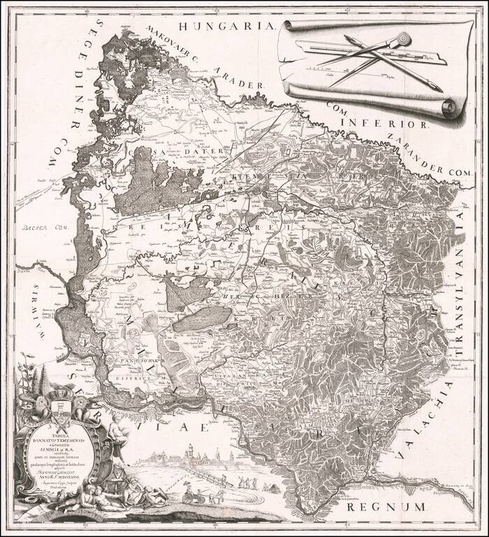
A Map of the Banat of Timisoara by One of its Most Important Historians
Rare separately published map of the Banat of Timișoara, created by Francesco Griselini, following his travels to Timișoara with Count Giuseppe Brigido in 1774 and published in Vienna.
The map is centered on Timișoara, and bounded by Zeged in the northwest, the Maros (Mures) River, in the north, Belgrade in the west and the Danube River in the south, covering a large portion of western Romania and northeastern Serbia, and a small portion of southeastern Hungary.
The map includes a city view which we assume to by Timișoara.
This map was one of the maps featured in the Harvard Map Collection's exhibition Look But Don’t Touch: Tactile Illusions on Maps at the Harvard Map Collection. In describing the map, Harvard Map Librarian David Weimer noted:
[The map illustrates] actual-size instruments for making a map — a compass, an 18-century mechanical pencil, a ruler — next to the actual map: this abstracted and scaled depiction of space . . . Griselini and his engraver, Augustinus Cipps, are playing with the flexibility of vision even as they tap into some of the philosophical debates that say that we need touch to understand the actual size of objects.
Strada Francesco Griselini in Timișoara is named for Griselini. As noted in his biography below, Griselini spent 2.5 years in the Banat of Timisoara, writing one of the first and most important histories of the region, before moving to Vienna in 1777.
Rarity
Grisellini's map is rare on the market. We find a single auction record for the map (Reiss & Sohn, 2008 -- 1,624 Euros).
OCLC locates 2 examples (Harvard, and Bavarische Staatsbibliothek).
If you are a student, write to us in telegram: @antiquemaps and indicate what material you need and for what work you need a map in high detail. We are ready to provide material on special terms. For students only!


