Map size in jpg-format: 14.1824MiB
Click to open in high resolution (open in new tab).
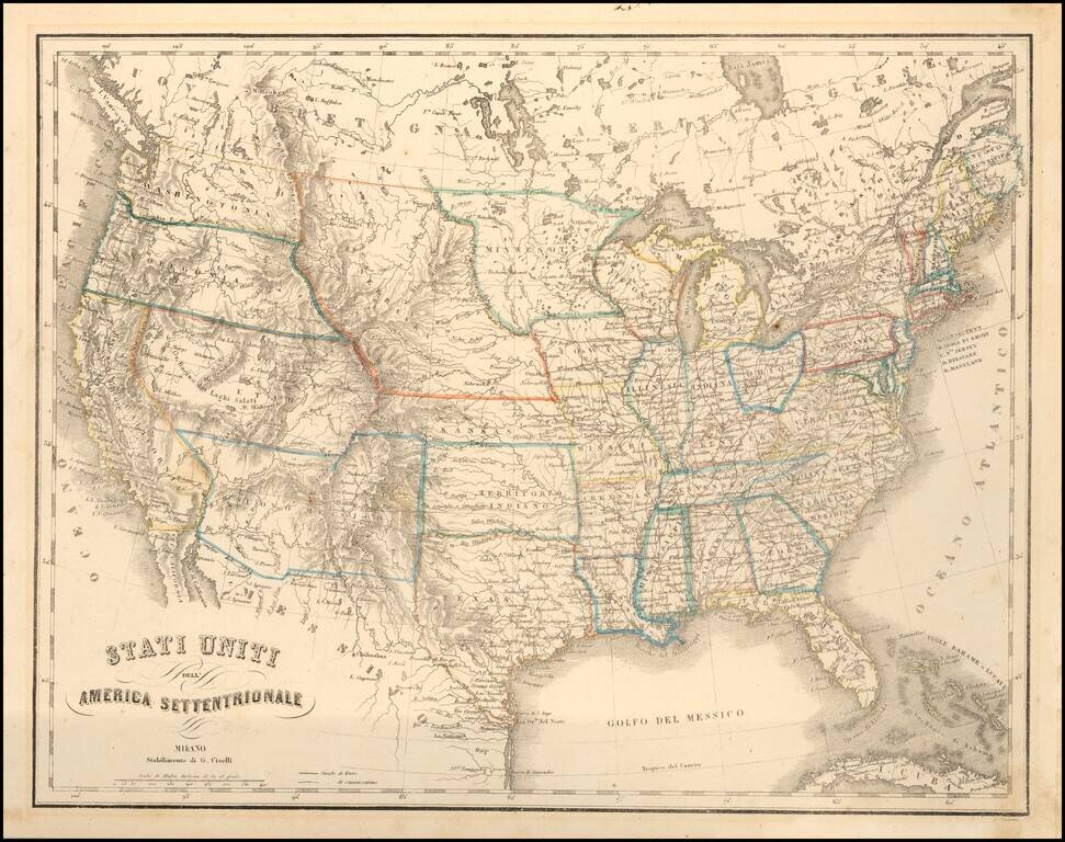
Interesting map of the United States, illustrating the western territories as they appeared from 1854 to 1860.
A scarce Italian produced map of the United States during a time of very interesting territorial borders just before the onset of the Civil War.
One of the most interesting features on the map is unusual appearance of Brownsville, Utah (1847-1851), the short-lived name of the town of Ogden, Utah, prior to its becoming chartered as the City of Ogden by the General Assembly of the State of Deseret in February 1851. Originally called Fort Buenaventura, it was noted as an excellent settlement location by Captain James Brown of the Mormon Battalion in 1847 and in November 1847, was purchased by the LDS Church from its owner, Miles Goodyear, on the instructions of Brigham Young. From January 1848 onward, it was available for free settlement to colonist who came north from Salt Lake. Originally called Brown's Settlement Ward or the Weber River Ward, it became the first LDS settlement in the future Weber County.
The appearance of Brownsville on an Italian map is quite curious.
Other features of note include Minnesota covering most of present day North and South Dakota. Nebraska and Kansas Territories fill the entire plains region with Nebraska extending all the way to the Canadian boundary. Washington and Oregon both extend eastward to the Rocky Mountains. Utah and New Mexico are both shown in their largest configurations. No sign yet of Arizona, Nevada, Colorado, Idaho, Wyoming, Montana or the Dakotas.
Several exploration routes are shown, including those of Fremont. Engraved by P. Bezzera.
If you are a student, write to us in telegram: @antiquemaps and indicate what material you need and for what work you need a map in high detail. We are ready to provide material on special terms. For students only!

![[Signed Political Satire Artwork] Vietnam ... Vietnam ... Vietnam ...](/map/small/68726.jpg)
