logo

1858. Specialkarte des Grossen Salzsee's von Utah Und Seiner Umgebungen. Nach den Aufnahmen von Freont und Stansbury . . . 1858

  • Specialkarte des Grossen Salzsee's von Utah Und Seiner Umgebungen.  Nach den Aufnahmen von Freont und Stansbury . . . 1858

Specialkarte des Grossen Salzsee's von Utah Und Seiner Umgebungen. Nach den Aufnahmen von Freont und Stansbury . . . 1858 information:

Year of creation: 
Resolution size (pixels): 
 1310x1644 px
Disk Size: 
 657720B
Number of pages: 
 1
Place: 
 Gotha

Print information. Print size (Width x height in inches):
Printing at 72 dpi 
  18.19 х 22.83
Printing at 150 dpi 
 8.73 х 10.96
Printing at 300 dpi 
 4.37 х 5.48

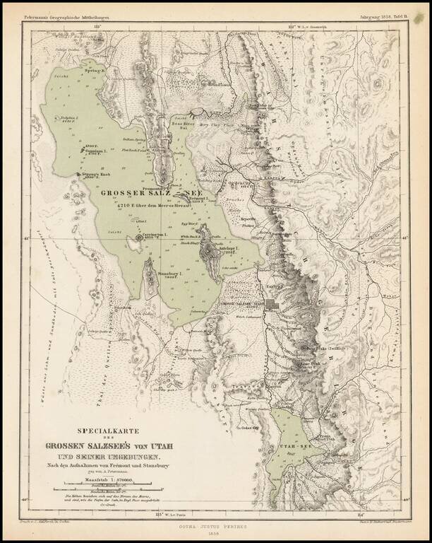
Scarce and highly detailed map of part of Utah in the Salt Lake and Wasatch region, published by Augustus Petermann.

The map names numerous early Utah towns, including:

  • Provo
  • Salt Lake City (with a town grid)
  • Springville
  • Brigham City
  • Palmyra
  • Payson
  • Pleasant Grove
  • Cedar City
  • Lake City
  • Welsh Settlement
  • Cottonwood
  • Kanyon
  • Farmington
  • Centerville
  • Phillips
  • Keysville
  • Ogden City
  • Bingham's Fort
  • Holmes
  • Haight
  • Muhle
  • Sessions

Many early roads are shown on both sides of the Wasatch Mountains.


Special conditions for students!

If you are a student, write to us in telegram: @antiquemaps and indicate what material you need and for what work you need a map in high detail. We are ready to provide material on special terms. For students only!

Item information:

Year of creation:
Size:
1310x1644 px
Disk:
657720B
Number of pages:
1
Place:
Gotha
Author:
Augustus Herman Petermann.
$9.99

Related item