Map size in jpg-format: 44.5591MiB
Click to open in high resolution (open in new tab).

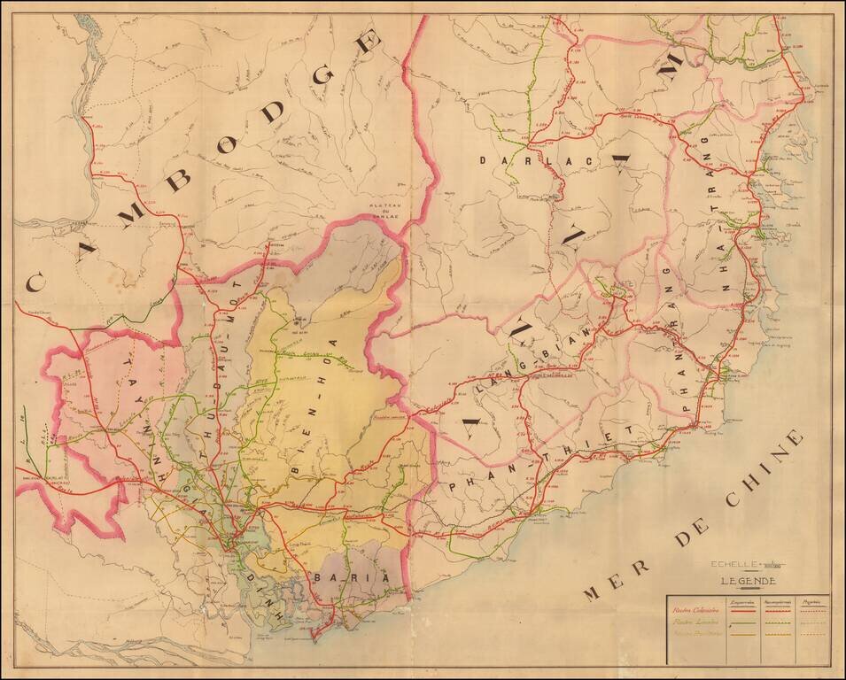
A Detailed French Study of the Roads in Southern Vietnam
Finely mauscript map of part of Southern Vietnam, drawn by an unknown French source.
The map focuses on the various roads throughout the region, all of which include distances in Kilometers at 10 Kilometer intervals.
Detailed manuscript map of Cochinchine from the Mekong to the region around Tuy Hòa in south central Vietnam.The section of Cambodia, as far over as the Mekong, is also shown but in less detail.
The map shows a railroad extending from Phan-Rang to Saigon.
The map legend identifies three types of roads
The roads are divided into three types of roads:
The map dates from the pre-World War II period.
If you are a student, write to us in telegram: @antiquemaps and indicate what material you need and for what work you need a map in high detail. We are ready to provide material on special terms. For students only!
![[Signed Political Satire Artwork] Vietnam ... Vietnam ... Vietnam ...](/map/small/68726.jpg)
![[Martin Behaim Globe / Book] Pars Globi terrestris Ao. 1492 a Martino Behaim Equite Lusitano Norimbergae confecti Delineavit Christoph. Theoph de Murr 1778 (bound with:) Diplomatische Geschichte des Portugesischen berühmten Ritters Martin Behaims](/map/small/68828.jpg)
![Il Disegno Della Terza Parte Dell' Asia [Gastaldi's Wall Map of SE Asia with extra panels!]](/map/small/30554hbp.jpg)