Map size in jpg-format: 34.8509MiB
Click to open in high resolution (open in new tab).
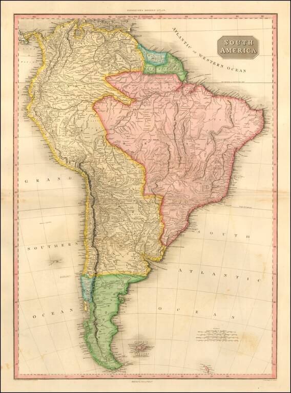
Striking and highly detailed map of South America, at the beginning of the major period of political upheaval on the Continent.
The map was produced immediately after Alexander Von Humboldt's visit, which spawned so much interest in the exploration and natural history of the Continent. The map reflects a nice blend of geographical knowledge and conjecture. While the geo-political borders still reflect the Spanish and Portuguese colonial influences, the map would be radically rewritten over the next 40 years. Pinkerton's now rare elephant folio atlas is one of the best engraved works of the period. While lesser known than the more common atlases by Cary & Thomson, it is a superior work, especially in the detail of the maps.
John Pinkerton (1758-1826) was Scottish literary critic, historian, poet, and geographer. From age twelve he educated himself at home in Edinburgh, as his father had declined to send him to university. His father instead apprenticed John to a lawyer, William Aytoun, but the boy did not like the legal profession. In his spare time, the young man wrote poetry and collected Scottish ballads, which he tried to have published. After the death of his father, Pinkerton moved to London in 1781, to be closer to the vibrant literary scene.
Pinkerton’s earliest publications were collections of ballads. However, a fellow critic uncovered that Pinkerton had forged several of the “ancient” poems and published accusations against Pinkerton in the Gentleman’s Magazine. Throughout the 1780s, Pinkerton published poetry, works on numismatics, and historical works. He corresponded with Sir Walter Scott, Horace Walpole, and Edward Gibbon, but most of his friendships ended in acrimony. Pinkerton was a hypochondriac, unorthodox about morality and religion, and a prickly personality who lived with several women during his lifetime, marrying illegally at least once.
After 1800, Pinkerton turned to geographical works. In 1802 he published Modern Geography, a text that was quite popular and translated into French and Italian. In 1808-15, he produced a New Modern Atlas, which was well received, followed by A General Collection of Voyages and Travels (1808-14). Soon after these projects, Pinkerton moved to Paris, where he lived until he died in 1826.
If you are a student, write to us in telegram: @antiquemaps and indicate what material you need and for what work you need a map in high detail. We are ready to provide material on special terms. For students only!


![[Signed Political Satire Artwork] Vietnam ... Vietnam ... Vietnam ...](/map/small/68726.jpg)