Map size in jpg-format: 11.3122MiB
Click to open in high resolution (open in new tab).
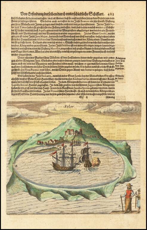
Early view of the Island of Solor in the Sunda Islands of Indonesia, from De Bry's Grand Voyages, an illustrated collection of accounts of the Americas which defined the early European picture of the New World.
Around 1570, Theodorus de Bry, a Protestant, fled religious persecution south to Strasbourg, along the west bank of the Rhine. In 1577, he moved to Antwerp in the Duchy of Brabant, where he further developed and used his skills as a copper engraver.
Between 1585 and 1588, De Bry worked and lived in London, where he met the geographer Richard Hakluyt and began to collect stories and illustrations of various European explorations, most notably from Jacques Le Moyne de Morgues. Depiction of Spanish atrocities in the New World, as recounted by Bartolome de las Casas in Narratio Regionum indicarum per Hispanos Quosdam devastatarum verissima. In 1588, De Bry and his family moved permanently to Frankfurt-am-Main, where he became citizen and began to plan his first publications. The most famous one is known as Les Grands Voyages, i.e., The Great Travels, or The Discovery of America. He also published the largely identical India Orientalis-series, as well as many other illustrated works on a wide range of subjects. His books were published in Latin, and were also translated into German, English and French to reach a wider reading public.
Theodor de Bry (1528-1598) was a prominent Flemish engraver and publisher best known for his engravings of the New World. Born in Liege, de Bry hailed from the portion of Flanders then controlled by Spain. The de Brys were a family of jewelers and engravers, and young Theodor was trained in those artisanal trades.
As a Lutheran, however, his life and livelihood was threatened when the Spanish Inquisition cracked down on non-Catholics. De Bry was banished and his goods seized in 1570. He fled to Strasbourg, where he studied under the Huguenot engraver Etienne Delaune. He also traveled to Antwerp, London, and Frankfurt, where he settled with his family.
In 1590, de Bry began to publish his Les Grands Voyages, which would eventually stretch to thirty volumes released by de Bry and his two sons. The volumes contained not only important engraved images of the New World, the first many had seen of the geographic novelties, but also several important maps. He also published a collection focus on India Orientalis. Les Grands Voyages was published in German, Latin, French, and English, extending de Bry’s fame and his view of the New World.
If you are a student, write to us in telegram: @antiquemaps and indicate what material you need and for what work you need a map in high detail. We are ready to provide material on special terms. For students only!

![[Sunda and Lilliput, etc. from Gulliver's Travels]](/map/small/54927.jpg)
