Map size in jpg-format: 24.9602MiB
Click to open in high resolution (open in new tab).
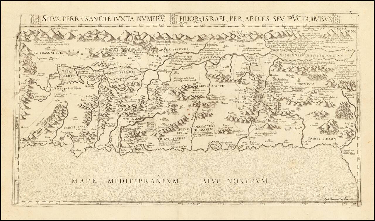
A Holy Land Rarity
The only known example of Donato Bertelli's map of the Holy Land, being a previously unknown state of Francesco Camocio's map of 1565.
Camocio's map, itself extremely rare, is a faithful copy of an earlier map by Antonio Salamanca, printed in Rome in 1548. Both maps have about the same dimensions, the same indications on the duration of the day and the same subdivision of by tribal territories. There are also many other similarities and some errors, such as the toponym Antibanus, instead of the correct Antilibanus.
The map is published for the first time without a signature by Camocio and only later Camocio adds its own signature. A third draft of the map, posthumously (1575), shows the removal of Camocio's name, likely by Donato Bertelli.
History of the Cartography of the Map
The map depicts the Holy Land with east at the top, drawn from the Medieval European Christian tradition of praying while facing eastwards, towards Jerusalem.
The map is drawn originally from Pietro Vesconte's map of 1320. The coast of the Holy Land is shown to run roughly flat along the Mediterranean Sea, The land is divided into the territories of the 12 Ancient Tribes of Israel and the landscape is adorned with many lengthy inscriptions discussing important locations and events from the bible, including an entertaining passage where Lot's wife was turned into a pillar of salt. It also shows the Sea of Galilee, with the River Jordan running into the Dead Sea, although it incorrectly shows a water connection between the Sea of Galilee and the Mediterranean.
Pietro Vesconte's map of the Holy Land, in its earliest form, survives in a circa 1320 manuscript work by Marino Sanudo. The Vesconte map is the single most important map of the Holy Land of the Late Medieval and Early Modern eras. The Vesconte-Sanudo map formed the basis for all of the early "tabulae moderna" ('new maps', meaning Post-Ptolemaic) of the Holy Land made during the first decades of printing. Around 1480, the cartographer Nicolaus Germanus created a map of the Holy Land which was based on the Vesconte map, but which contained notable revisions. Germanus's map was published in both Francesco Berlinghieri's edition of Ptolemy's Geographia (Rome, 1482) and Lienhart Holle's edition of Ptolemy (Ulm, 1482). Germanus's work was reissued on many subsequent occasions, including by Martin Waldseemüller in 1513.
States of the Map
The map is known in at least four states, all extremely rare:
Rarity
This is the final edition of the map bears the address "Apud Donatum Bertellum", the only known copy, from the Fritz Hellwig collection, was sold at Reiss & Sohn, May 2019 and was previously unrecorded.
In 2007, State 2 of the map (trimmed to inside neatlines and remargined) was sold for $34,160 (Paulus Swaen, Oct 9, 2007, Lot 25018).
If you are a student, write to us in telegram: @antiquemaps and indicate what material you need and for what work you need a map in high detail. We are ready to provide material on special terms. For students only!


![[Early Montanus World Map in Volume Eight of the Plantin Polyglot Bible]](/map/small/53766.jpg)