Map size in jpg-format: 76.3119MiB
Click to open in high resolution (open in new tab).
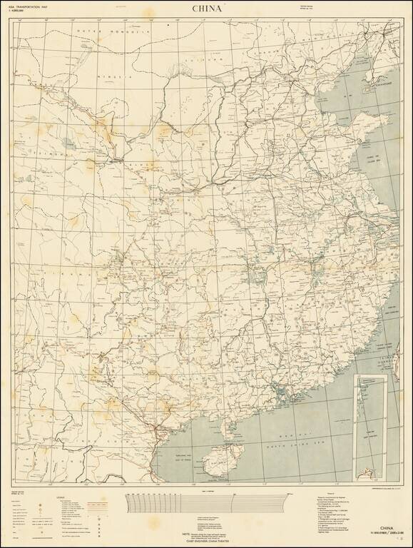
RESTRICTED - U.S. Military Mapping of China During the Final Stages of the Second World War.
Color-printed separately issued map of China, part of the "Asia Transportation Map" Restricted series. This is the "Theater Edition" (i.e., for use in China) Revised to April 1945.
The map includes seven types of road classification, and perhaps most interestingly, differentiates Overnight Stops:
The map shows the Ledo Road, the main overland connection between India and China built during World War II to enable the Western Allies to deliver supplies to China. Here the road is shown in detail coming out of Burma. Distance and road conditions are shown, as well as the network that fanned out across China from the main Ledo artery.
The U.S. military was clearly looking to improve upon its knowledge of China, as a large note at the bottom reads: "NOTE: Persons using this map will mark hereon corrections and additions which come to their attention and mail direct to CHIEF ENGINEER, CHINA THEATER."
The 653rd Engineer Topographic Battalion was a mapmaking arm of the United States Air Force, stationed in India. The battalion produced maps for a host of military situations, including the major U.S.A.F. activities in and around China. The battalion also produced "walk-out maps" for the Office of Strategic Service. One of the first Japanese targets for the XXth Bomber Command's B-29 raids from China was Nagasaki, a center of Japanese munitions production. The target chart for that raid was reproduced by the 653d in September 1944.
If you are a student, write to us in telegram: @antiquemaps and indicate what material you need and for what work you need a map in high detail. We are ready to provide material on special terms. For students only!
![[Martin Behaim Globe / Book] Pars Globi terrestris Ao. 1492 a Martino Behaim Equite Lusitano Norimbergae confecti Delineavit Christoph. Theoph de Murr 1778 (bound with:) Diplomatische Geschichte des Portugesischen berühmten Ritters Martin Behaims](/map/small/68828.jpg)
![Il Disegno Della Terza Parte Dell' Asia [Gastaldi's Wall Map of SE Asia with extra panels!]](/map/small/30554hbp.jpg)
![Chinae, olim Sinarum regionis nova descriptio. auctore Ludouico Georgio. [English Edition!]](/map/small/71123.jpg)