logo

1593. Saxonum Regionis Quatenus Eius Gentis Imperium Nomenque olim patebat, recens germanaque deleatio, Christiano Schrotenio authore . . .

  • Saxonum Regionis Quatenus Eius Gentis Imperium Nomenque olim patebat, recens germanaque deleatio, Christiano Schrotenio authore . . .

Saxonum Regionis Quatenus Eius Gentis Imperium Nomenque olim patebat, recens germanaque deleatio, Christiano Schrotenio authore . . . information:

Year of creation: 
Resolution size (pixels): 
 12003x9086 px
Disk Size: 
 34.8569MiB
Number of pages: 
 1
Place: 
 Antwerp
Author: 

Print information. Print size (Width x height in inches):
Printing at 72 dpi 
  166.71 х 126.19
Printing at 150 dpi 
 80.02 х 60.57
Printing at 300 dpi 
 40.01 х 30.29

An example of detailing the file of this map of in a printable high-resolution:

Click to open in high resolution (open in new tab).
Attention! this is just the central piece (central area 960x960 px) of the map file!
This is an example, so that you can see and study the level of detail of a given map. The entire Map will be fully available after payment!

Saxonum Regionis Quatenus Eius Gentis Imperium Nomenque olim patebat, recens germanaque deleatio, Christiano Schrotenio authore . . .

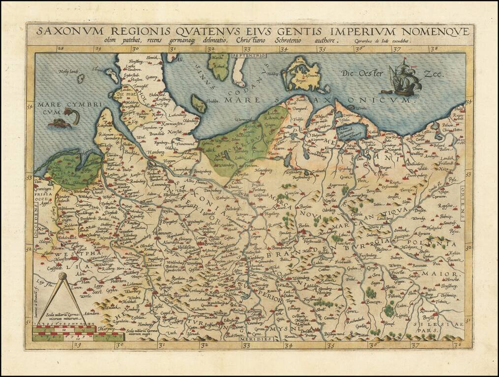
Fine old color example of Gerard de Jode's map of Northern Germany and Western Poland.

The North Sea is adorned by a fish and the Baltic Sea by a sailing ship, and the borders of Schleswig-Posen-Dresden-Groningen are featured.

The map is based on Christian Sgrothen's manuscript atlas of the region and was engraved by Johannes van Deutecum.

Gerard De Jode (1509-1591) was a pre-eminent mapmaker in the late seventeenth century, a time when the Dutch dominated the map trade. He was known for his many maps, some of which featured in Speculum Orbis Terrae (first edition Antwerp: 1578). Although never as successful as Ortelius’ Theatrum, the Speculum did get republished in a second edition in 1593, two years after De Jode’s death, by Arnold Coninx, and included this map. After his death, Gerard’s son, Cornelis (1568-1600), and his wife, Paschina, ran the shop. Unfortunately, Cornelis died young in 1600, aged only 32, and the stock and plates were sold to the publisher Joan Baptista Vrients.  


Special conditions for students!

If you are a student, write to us in telegram: @antiquemaps and indicate what material you need and for what work you need a map in high detail. We are ready to provide material on special terms. For students only!

Item information:

Year of creation:
Size:
12003x9086 px
Disk:
34.8569MiB
Number of pages:
1
Place:
Antwerp
Author:
Gerard de Jode.
$14.99

Related item