Map size in jpg-format: 80.2396MiB
Click to open in high resolution (open in new tab).
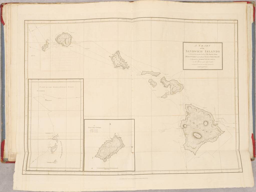
Fine and Rare Admiralty Chart of the Sandwich Islands from the First Government Survey of Hawaii
Good example of Admiralty chart of the Hawaiians Islands, then known as the Sandwich Islands, with input from the first trigonometric survey of the islands. Previously, the most accurate charting came from European voyagers who briefly touched at the islands or sailed around them. This particular example is all the more special because it was sold by the Admiralty agent in Melbourne, Australia, and made during the tenure of the influential Hydrographer of the Royal Navy Frederick John Evans.
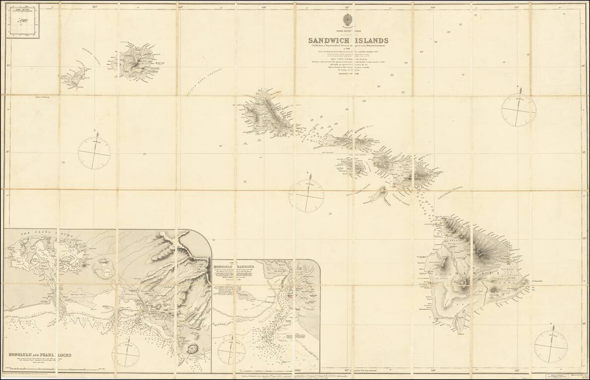
The chart shows the Hawaiian archipelago. There are several variation compasses scattered around the islands, and the simple title is in the upper center of the chart. In the upper left corner is a tiny inset of Bird Island, while much larger insets of Honolulu and the Pearl Lochs and Honolulu Harbor are joined in the lower left corner.
The Hawaiian Islands had been charted using Western methods since Cook made contact in 1778. His chart, as well as those made by men on the La Perouse, Dixon and Portlock, Quimper, Ingraham, Vancouver and von Krusenstern expeditions all added to the geographic knowledge of the islands. For more, see here . These expeditions seldom stayed long, however, and did not venture far inland.
Hawaiian Government Survey
In 1870, the Kingdom of Hawaii set up a Hawaiian Government Survey to discern and regulate the distribution of public land. It also sought to update the explorers' maps that were still used decades after their creation. There had been prior magnetic surveys conducted for the Land Commission and Interior Department, but they were neither systematic nor large-scale. The new survey was conducted using triangulation with consistent base lines. Led by W. D. Alexander and C. J. Lyons, work commenced on Maui and then spread to other islands. By 1880, just before this chart was published, the survey had covered most of Maui, Hawaii, Oahu, Lanai, and the surveyors were working on Molokai.
The Hawaiian Survey shared their work, and the British Admiralty, whose practice it was to continually update their charts with new information, gladly integrated the data into their existing chart of the Sandwich Islands. They also used sounding depths from the USS Tuscarora and the HMS Challenger. In 1874, the Tuscarora was dispatched to sound depths prior to laying a cable between the US, Japan, and China. While in the Pacific from 1874 to 1879, Tuscarora visited Honolulu many times, as it was a naval hub.
HMS Challenger served as the flagship of the Australia Station of the Royal Navy from 1866 to 1870. From 1873 to 1876, Challenger toured the world on a grand scientific tour organized by the University of Edinburgh and the Royal Society. The ship carried naturalists, oceanographers, and other scientists and eventually published multiple books on their findings. One of the many special refits the ship received prior to sailings was extra rope for sounding and a reduction in guns so as to fit more dredging containers and sample jars. They sounded the deepest part of the ocean, now known as Challenger Deep, and, for the purposes of this map, visited Hawaii in 1875.
The inset of Pearl Lochs was taken from various surveys made between 1840 and 1879, but the Honolulu Harbor inset came specifically from the survey of G.E.G. Jackson in 1830 and the surveys of 1856 and 1863 by T. A. Hall and G. H. Richards, respectively. This layering of surveys is indicative of the archive at the Hydrography Office's disposal. They could call on mass amounts of data to populate their charts, which is why they were widely considered as the best in the world at the time.
They also sold their maps around the world; this example was sold in Melbourne by J. Donne & Son, official Admiralty chart agents. Their firm is still selling maps today.
The cartographic influence of Frederick John Evans at the Admiralty
This particular map was made under the supervision of Captain F. J. Evans (1815-1885), a surveyor who had worked in the Hydrography Office since the 1850s. Early in his career, Evans served as master on the Fly, which surveyed great swaths of the eastern Pacific from 1841 to 1846. Then, from 1847 to 1851 he surveyed much of New Zealand on the Acheron. In 1855 he received the post of Superintendent of the Compass Department of the Royal Navy where he and Archibald Smith devised how to overcome interference with compasses aboard iron ships. This work saw him publish seven papers on magnetism and got him elected a Fellow of the Royal Society in 1862. In 1865 he became chief naval assistant to the Hydrographer of the Navy and then succeeded to that position in 1884. He resigned the post in 1885 and was then chosen as a British delegate to the International Meridian Conference, which chose Greenwich as the location for the Prime Meridian. He died in London in 1885.
The map itself was engraved by Edward Weller (1819-1884), a successful engraver and cartographer. He was a Fellow of the Royal Geographical Society and the unofficial cartographer to the Society; he produced over 100 maps for their journal.
Rarity
The map is scarce, with no copies listed in OCLC.
If you are a student, write to us in telegram: @antiquemaps and indicate what material you need and for what work you need a map in high detail. We are ready to provide material on special terms. For students only!
![Map of Mexico, Central America, and the West Indies [Insets of Bermuda, Sandwich Islands, Jamaica and Panama Railroad]](/map/small/69133.jpg)