Map size in jpg-format: 2.93035MiB
Click to open in high resolution (open in new tab).
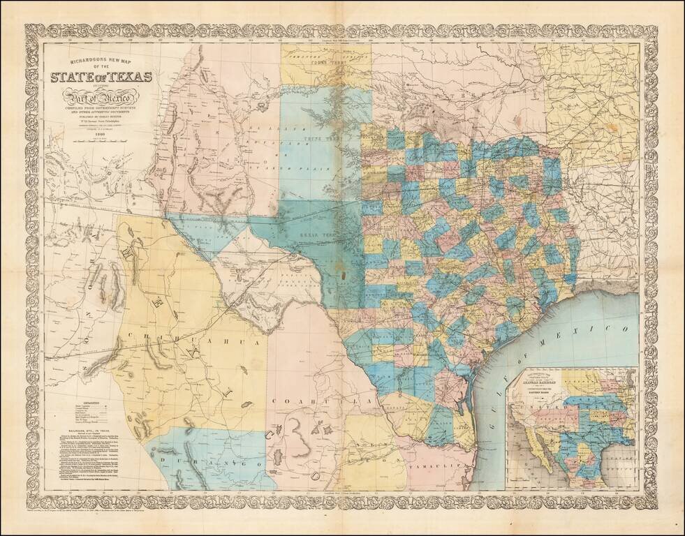
Fine large format map of Texas, published in 1860.
Richardson's map was one of the best and most accurate maps of Texas on the eve of the Civil War. Hand Colored by counties, it is of particular not for its excellent depiction of the existing and planned railroads operating within the State of Texas. The Mail Road to San Diego, Mail Road to El Paso and County & Stage roads are also separately delineated.
Rumsey notes:
This is an exceptionally attractive map of Texas on the eve of the Civil War. . . . Railroads completed and in progress are particularly well delineated, and a box of text in the lower left corner lists the completed railroads and their proposed extensions as well as one canal, the Galveston Bay and Brazos River. In the lower right is an inset map of the proposed route of the Arkansas Railroad. The topography, coasts and rivers are accurately delineated, with the source being the outstanding Map of Texas and part of Mexico, 1857, issued by the Bureau of Topographical Engineers . . . . Pressler's Map of the State of Texas, 1858, is a secondary source, as is J.H. Young's Map of the State of Texas which was published in Desilver's 1859 (Mitchell's) New Universal Atlas. Richardson's map is a serious production, far more up to date than the Colton, Johnson, or Desilver/Mitchell atlas maps of 1861, and more accurate in west Texas, southern New Mexico and northern Mexico than the Pressler 1858 Texas . . . .Issued separately as an extra add on to Richardson's Almanac, it was unquestionably one of the most influential separately published large format maps of Texas of the period and enjoyed wide spread circulation.
If you are a student, write to us in telegram: @antiquemaps and indicate what material you need and for what work you need a map in high detail. We are ready to provide material on special terms. For students only!


