logo

1843. Republica Mexicana Plano de la Parte Austral Del Istmo de Tehuantepec Desde La Costa Del Oceano Pacifico Hasta La Llanura Del Coatzacoalcos Levantado por disposicion de Dn. Jose de Garay empressario de la comunicationb Oceanica apor la comision cientifica

  • Republica Mexicana Plano de la Parte Austral Del Istmo de Tehuantepec Desde La Costa Del Oceano Pacifico Hasta La Llanura Del Coatzacoalcos Levantado por disposicion de Dn. Jose de Garay empressario de la comunicationb Oceanica apor la comision cientifica

Republica Mexicana Plano de la Parte Austral Del Istmo de Tehuantepec Desde La Costa Del Oceano Pacifico Hasta La Llanura Del Coatzacoalcos Levantado por disposicion de Dn. Jose de Garay empressario de la comunicationb Oceanica apor la comision cientifica information:

Year of creation: 
Resolution size (pixels): 
 10766x13198 px
Disk Size: 
 34.6065MiB
Number of pages: 
 1
Place: 
 n.p.
Author: 

Print information. Print size (Width x height in inches):
Printing at 72 dpi 
  149.53 х 183.31
Printing at 150 dpi 
 71.77 х 87.99
Printing at 300 dpi 
 35.89 х 43.99

An example of detailing the file of this map of in a printable high-resolution:

Click to open in high resolution (open in new tab).
Attention! this is just the central piece (central area 960x960 px) of the map file!
This is an example, so that you can see and study the level of detail of a given map. The entire Map will be fully available after payment!

Republica Mexicana Plano de la Parte Austral Del Istmo de Tehuantepec Desde La Costa Del Oceano Pacifico Hasta La Llanura Del Coatzacoalcos Levantado por disposicion de Dn. Jose de Garay empressario de la comunicationb Oceanica apor la comision cientifica

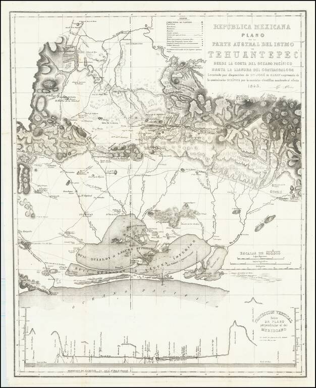
Rare map of the southern portion of the Isthmus of Tehuantepec, with Laguna Superior abutting the Pacific Ocean. At bottom is a profile showing elevations across the isthmus.

The map is the result of the surveys undertaken by Don Jose de Garay, between 1842 and 1843,

In the 1830 and 1840s, many governments and investors were constantly seeking an economically viable means of shortening the distance by sea between the Atlantic Coast and Pacific Coast. The Isthmus of Tehuantepec represented the shortest distance between the Gulf of Mexico and the Pacific Ocean, and prior to the opening of the Panama Canal. The privilege of constructing a means of transit for crossing the Isthmus of Tehuantepec was granted by Mexico to Don José de Garay (1801-1858).

Garay made a survey of the land which was finished in February of 1843.


Special conditions for students!

If you are a student, write to us in telegram: @antiquemaps and indicate what material you need and for what work you need a map in high detail. We are ready to provide material on special terms. For students only!

Item information:

Year of creation:
Size:
10766x13198 px
Disk:
34.6065MiB
Number of pages:
1
Place:
n.p.
Author:
Cayetano Moro.
$14.99

Related item