Map size in jpg-format: 61.1504MiB
Click to open in high resolution (open in new tab).

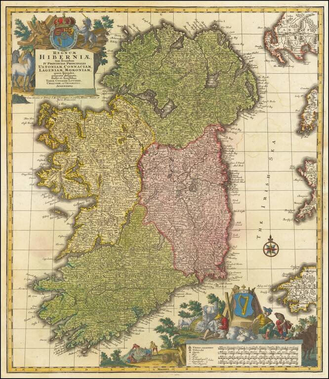
A finely colored example of Lotter's decorative map of Ireland, colored by regions and showing towns, roads, counties, rivers, lakes, castles, and more. Ireland is visible in its entirety, divided into its four provinces: Ulster in the north, Connacht in the west, Leinster in the east, and Munster in the south. Part of Galloway, the Isle of Man, and Cornwall are all also shown. The map includes two marvelous cartouches, coats of arms, and allegorical details.
The contrast between the two coats of arms is interesting. The one on the bottom left shows the Celtic Harp, a symbol of Ireland, and is framed by pastoral scenes, including shepherds with their flocks and fishermen. The other coat of arms is in the upper left, this is the coat of arms of the United Kingdom and it is framed by a much more regal and powerful scene, including the English lion and the Scottish unicorn. The balance of power is clearly evident; this leaves the impression of looking at a minor constituent kingdom rather than a nation among equals.
That being said, the attention to detail on the map is extensive. The many place names provided allow for a fascinating picture of how Ireland stood in the mid-18th century. Particularly interesting is the fact that the only religious institutions shown appear to be those of the Church of Ireland. Evidence from this comes from the archbishop seat shown at Armagh, which was only regularly occupied by the Primate of Ireland in the Church of England. The map was made during the Protestant Ascendancy, a period in which Catholics were increasingly persecuted and Protestants controlled almost all the power. Intriguingly, Dublin is not shown as being the seat of an archbishop, though it was at the time.
Lotter used an earlier plate from a Seutter circa 1740 map to make this present example.
Tobias Conrad Lotter (1717-1777) is one of the best-known German mapmakers of the eighteenth century. He engraved many of the maps published by Matthaus Seutter, to whose daughter Lotter was married. He took over Seutter’s business in 1756. Lotter’s son, M. A. Lotter, succeeded his father in the business.
If you are a student, write to us in telegram: @antiquemaps and indicate what material you need and for what work you need a map in high detail. We are ready to provide material on special terms. For students only!
![Johnson's Ireland [with] Johnson's Scotland](/map/small/71010.jpg)