logo

1649. Provincia Flandriae

  • Provincia Flandriae

Map size in jpg-format: 2.21221MiB

Download "Provincia Flandriae", in high resolution.

Provincia Flandriae information:

Year of creation: 
Resolution size (pixels): 
 2679x3673 px
Disk Size: 
 2.21221MiB
Number of pages: 
 1
Place: 
 Milan

Print information. Print size (Width x height in inches):
Printing at 72 dpi 
  37.21 х 51.01
Printing at 150 dpi 
 17.86 х 24.49
Printing at 300 dpi 
 8.93 х 12.24

An example of detailing the file of this map of in a printable high-resolution:

Click to open in high resolution (open in new tab).
Attention! this is just the central piece (central area 960x960 px) of the map file!
This is an example, so that you can see and study the level of detail of a given map. The entire Map will be fully available after payment!

Provincia Flandriae

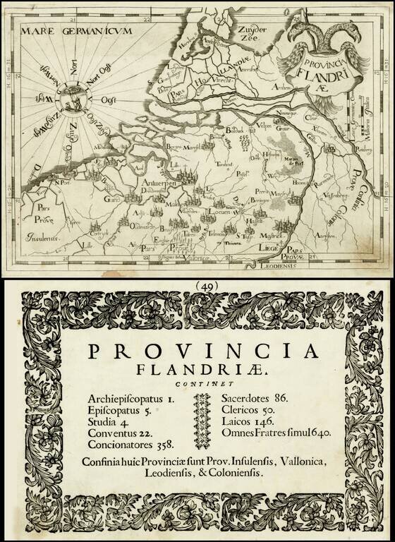
Rare map of the "Province of Flanders" by Johannes A. Montecalerio, published in Chorographica Descriptio Provinciaru & Conventum… in Milan.

The engraving style is bold and unique, not at all similar to contemporary cartographers. There were two editions of Montecalerio's work, the second published in Turin in 1712.


Special conditions for students!

If you are a student, write to us in telegram: @antiquemaps and indicate what material you need and for what work you need a map in high detail. We are ready to provide material on special terms. For students only!

Item information:

Year of creation:
Size:
2679x3673 px
Disk:
2.21221MiB
Number of pages:
1
Place:
Milan
Author:
Johannes A. Montecalerio.
$14.99

Related item