logo

1700. Principaute De Catalogne. Ou sont compris Les Comtes de Roussillon et de Cerdagne divises en leurs Vigueries (Including 32 additional Catalan City Plans on 4 sheets)

  • Principaute De Catalogne. Ou sont compris Les Comtes de Roussillon et de Cerdagne divises en leurs Vigueries  (Including 32 additional Catalan City Plans on 4 sheets)
  • Principaute De Catalogne. Ou sont compris Les Comtes de Roussillon et de Cerdagne divises en leurs Vigueries  (Including 32 additional Catalan City Plans on 4 sheets)
  • Principaute De Catalogne. Ou sont compris Les Comtes de Roussillon et de Cerdagne divises en leurs Vigueries  (Including 32 additional Catalan City Plans on 4 sheets)
  • Principaute De Catalogne. Ou sont compris Les Comtes de Roussillon et de Cerdagne divises en leurs Vigueries  (Including 32 additional Catalan City Plans on 4 sheets)

Principaute De Catalogne. Ou sont compris Les Comtes de Roussillon et de Cerdagne divises en leurs Vigueries (Including 32 additional Catalan City Plans on 4 sheets) information:

Year of creation: 
Resolution size (pixels): 
 22672x14889 px
Disk Size: 
 53.7568MiB
Number of pages: 
 5
Place: 
 Paris

Print information. Print size (Width x height in inches):
Printing at 72 dpi 
  314.89 х 206.79
Printing at 150 dpi 
 151.15 х 99.26
Printing at 300 dpi 
 75.57 х 49.63

An example of detailing the file of this map of in a printable high-resolution:

Click to open in high resolution (open in new tab).
Attention! this is just the central piece (central area 960x960 px) of the map file!
This is an example, so that you can see and study the level of detail of a given map. The entire Map will be fully available after payment!

Principaute De Catalogne. Ou sont compris Les Comtes de Roussillon et de Cerdagne divises en leurs Vigueries  (Including 32 additional Catalan City Plans on 4 sheets)

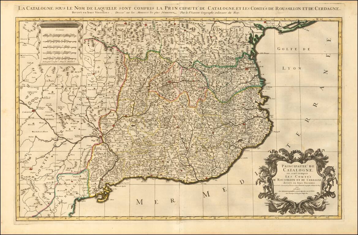
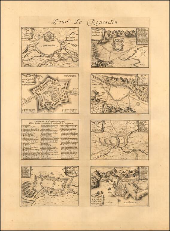
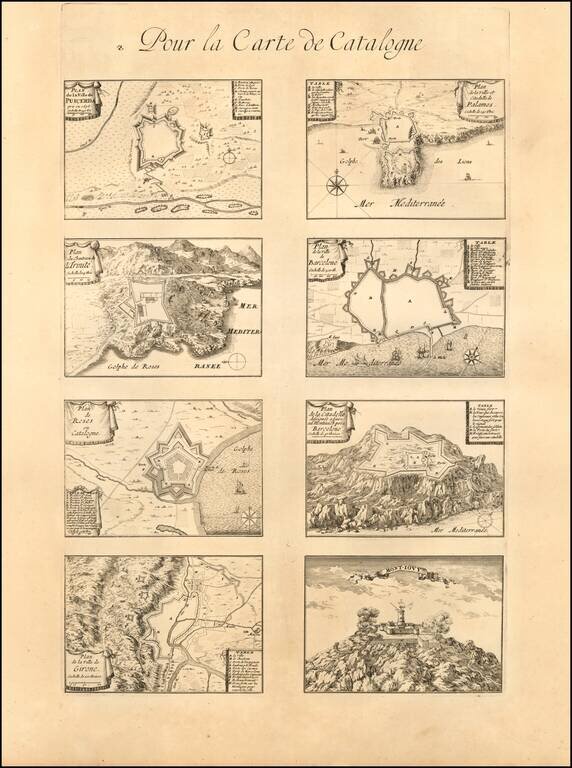
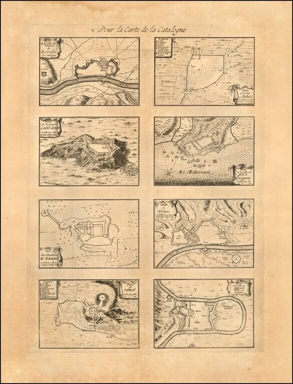
Striking large and highly detailed map of Catalonia, with a large decorative cartouche and a scale of distance. In addition, there are 4 separate sheets, each with an accompanying set 8 town plans and birdseye views, including Roussilon, Perpignan (capital of Roussilon), Catalonia, Puicera, Palamos, Barcelona, Girone, Castel-Dazen, Lerida, Tortose, Ceruere, Balaguier, etc.

These large format Jaillot maps with the extra view sheets are quite rare on the market. A fine decorative example with wide clean margins. From Jaillot's monumental atlas.

One of the best large format maps of Catalonia from the late 17th Century to appear in a commercial atlas.

Alexis-Hubert Jaillot (ca. 1632-1712) was one of the most important French cartographers of the seventeenth century. Jaillot traveled to Paris with his brother, Simon, in 1657, hoping to take advantage of Louis XIV's call to the artists and scientists of France to settle and work in Paris. Originally a sculptor, he married the daughter of Nicholas Berey, Jeanne Berey, in 1664, and went into partnership with Nicholas Sanson's sons. Beginning in 1669, he re-engraved and often enlarged many of Sanson's maps, filling in the gap left by the destruction of the Blaeu's printing establishment in 1672.


Special conditions for students!

If you are a student, write to us in telegram: @antiquemaps and indicate what material you need and for what work you need a map in high detail. We are ready to provide material on special terms. For students only!

Item information:

Year of creation:
Size:
22672x14889 px
Disk:
53.7568MiB
Number of pages:
5
Place:
Paris
Author:
Alexis-Hubert Jaillot.
$21.99

Related item