Map size in jpg-format: 36.6887MiB
Click to open in high resolution (open in new tab).
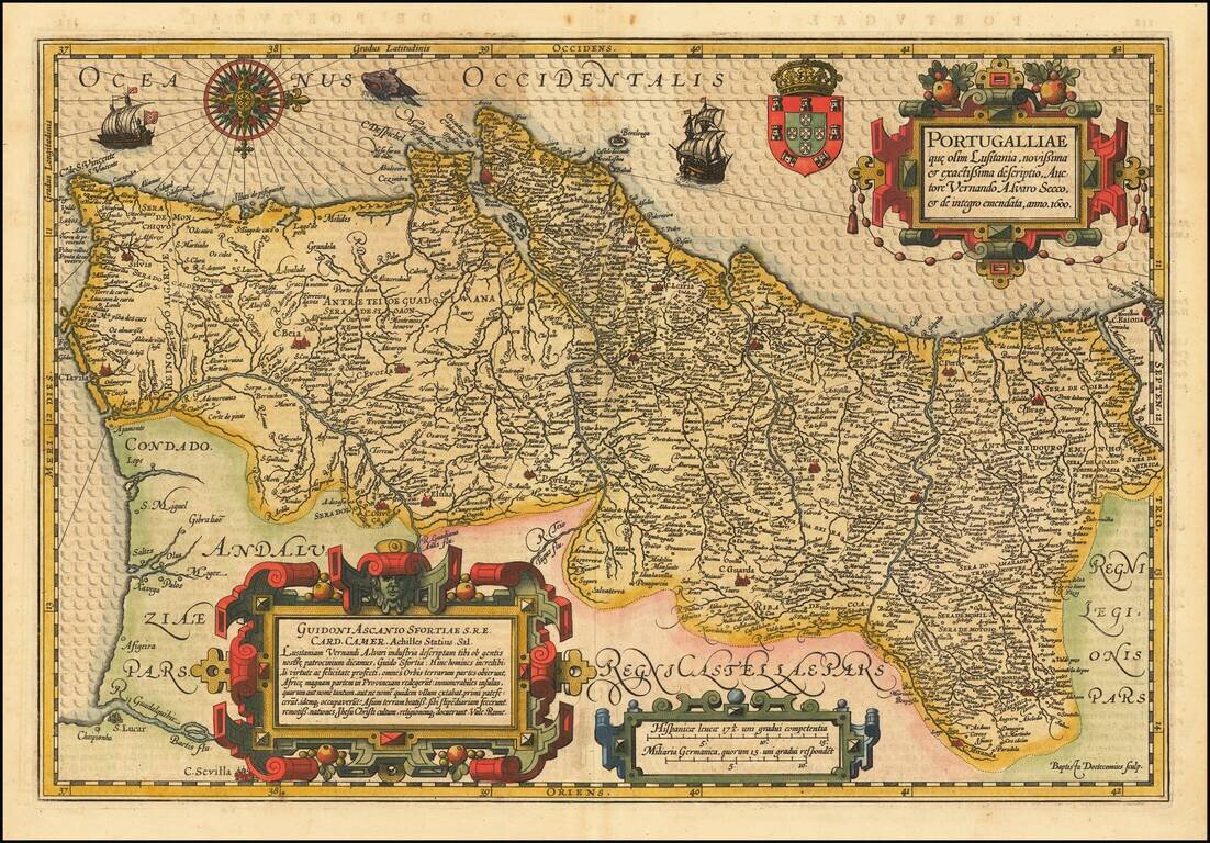
Fine example of one of the most beautiful of all maps of Portugal published in the 17th Century.
This is one of the few maps engraved by Baptista van Doetecum for the Hondius Mercator Atlas and demonstrates the elegant style of one of the great master engravers of the early 17th Century. The map is a based upon Alvares Secco's map of 1561.
Richly embellished with cartouches, compass rose, sailing ships, coat of arms, and a sea monster.
Jodocus Hondius the Elder (1563-1612), or Joost de Hondt, was one of the most prominent geographers and engravers of his time. His work did much to establish Amsterdam as the center of cartographic publishing in the seventeenth century. Born in Wakken but raised in Ghent, the young Jodocus worked as an engraver, instrument maker, and globe maker.
Hondius moved to London in 1584, fleeing religious persecution in Flanders. There, he worked for Richard Hakluyt and Edward Wright, among others. Hondius also engraved the globe gores for Emery Molyneux’s pair of globes in 1592; Wright plotted the coastlines. His engraving and nautical painting skills introduced him to an elite group of geographic knowledge seekers and producers, including the navigators Drake, Thomas Cavendish, and Walter Raleigh, as well as engravers like Theodor De Bry and Augustine Ryther. This network gave Hondius access to manuscript charts and descriptions which he then translated into engraved maps.
In 1593 Hondius returned to Amsterdam, where he lived for the rest of his life. Hondius worked in partnership with Cornelis Claesz, a publisher, and maintained his ties to contacts in Europe and England. For example, from 1605 to 1610, Hondius engraved the plates for John Speed’s Theatre of the Empire of Great Britaine.
One of Hondius’ most successful commercial ventures was the reprinting of Mercator’s atlas. When he acquired the Mercator plates, he added 36 maps, many engraved by him, and released the atlas under Mercator’s name, helping to solidify Mercator’s reputation posthumously. Hondius died in 1612, at only 48 years of age, after which time his son of the same name and another son, Henricus, took over the business, including the reissuing of the Mercator atlas. After 1633, Hondius the Elder’s son-in-law, Johannes Janssonius, was also listed as a co-publisher for the atlas.
If you are a student, write to us in telegram: @antiquemaps and indicate what material you need and for what work you need a map in high detail. We are ready to provide material on special terms. For students only!