Map size in jpg-format: 3871980B
Click to open in high resolution (open in new tab).
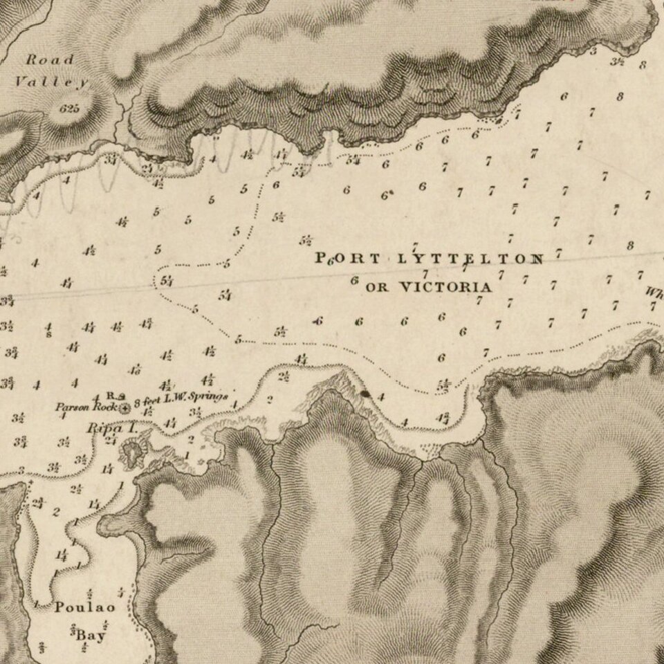
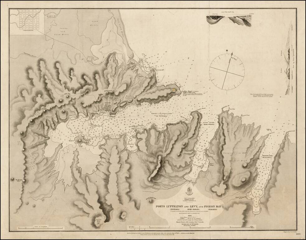
Finely executed chart showing Port Lyttelton and environs, extending north to Christchurch.
The chart extends the area from north of the Avon and Heathcote Estuary down to beyond Pigeon Bay, showing the soundings in fathoms from the Estuary outlet to the entrance of Port Levy, and Pigeon Bay. The chart provides fine hydrographical and topographical details, including soundings, the location of the lighthouse at Godley Head, and a note that the Lyttleton Hr. Commn. recommended a location for a breakwater and Beacon in 1863.
The primary surveyor for the chart, John Lort Stokes, gained his initial acclaim as an officer in the Royal Navy who travelled on HMS Beagle for 18 years. Following the second voyage of the Beagle, Stokes was promoted to lieutenant, and served under Commander John Clements Wickham for a survey of Australasian waters. When Wickham was invalided in 1841, Stokes took command of the ship. While Stokes was in command the Beagle surveyed Timor and New Zealand. When he returned he wrote Discoveries in Australia, with an account of the coasts and rivers explored and surveyed during the voyage of the Beagle, 1837-1843.
In July 1846, Stokes was promoted to captain and commanded the Acheron, surveying New Zealand for four years. From 1860 to 1863 he commanded the ship HMS Rose surveying the coasts of the English Channel. He retired in 1863, was promoted to the rank of rear admiral in 1863, vice-admiral in 1871 and admiral in 1877.
The survey work by Stokes was completed at the same time as the work of Joseph Thomas, the chief surveyor for Lyttelton, Sumner, and Christchurch, on behalf of the Canterbury Association, who arrived in New Zealand in November 1848, with his chief purpose being to find a suitable place for a proposed settlement, which would become Christchurch (located on this map).
The British Admiralty has produced nautical charts since 1795 under the auspices of the United Kingdom Hydrographic Office (HO). Its main task was to provide the Royal Navy with navigational products and service, but since 1821 it has also sold charts to the public.
In 1795, King George III appointed Alexander Dalrymple, a pedantic geographer, to consolidate, catalogue, and improve the Royal Navy’s charts. He produced the first chart as the Hydrographer to the Admiralty in 1802. Dalrymple, known for his sticky personality, served until his death in 1808, when he was succeeded by Captain Thomas Hurd. The HO has been run by naval officers ever since.
Hurd professionalized the office and increased its efficiency. He was succeeded by the Arctic explorer Captain William Parry in 1823. By 1825, the HO was offering over seven hundred charts and views for sale. Under Parry, the HO also began to participate in exploratory expeditions. The first was a joint French-Spanish-British trip to the South Atlantic, a voyage organized in part by the Royal Society of London.
In 1829, Rear-Admiral Sir Francis Beaufort was appointed Hydrographer Royal. Under his management, the HO introduced the wind force scale named for him, as well as began issuing official tide tables (1833). It was under Beaufort that HMS Beagle completed several surveying missions, including its most famous voyage commanded by Captain FitzRoy with Charles Darwin onboard. When Beaufort retired in 1855, the HO had nearly two thousand charts in its catalog.
Later in the nineteenth century, the HO supported the Challenger expedition, which is credited with helping to found the discipline of oceanography. The HO participated in the International Meridian Conference which decided on the Greenwich Meridian as the Prime Meridian. Regulation and standardization of oceanic and navigational measures continued into the twentieth century, with the HO participating at the first International Hydrographic Organization meeting in 1921.
During World War II, the HO chart making facility moved to Taunton, the first purpose-built building it ever inhabited. In 1953, the first purpose-built survey ship went to sea, the HMS Vidal. Today, there is an entire class of survey vessels that make up the Royal Navy’s Hydrographic Squadron. The HO began to computerize their charts in the late 1960s and early 1970s. In 1968, the compilation staff also came to Taunton, and the HO continues to work from there today.
If you are a student, write to us in telegram: @antiquemaps and indicate what material you need and for what work you need a map in high detail. We are ready to provide material on special terms. For students only!

![Pascaart vertoonende de zeecusten van Chili, Peru, Hispania Nova, Nova Granada, en California…. [Early New Zealand Inset]](/map/small/65168.jpg)