Map size in jpg-format: 3.06093MiB
Click to open in high resolution (open in new tab).
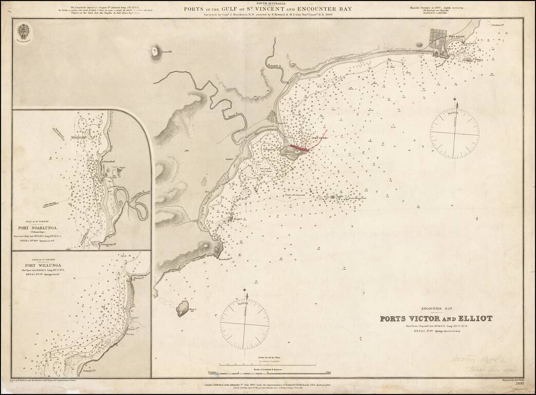
Fine example of the first edition of this early Admiralty Chart showing the ports in the Gulf of St. Vincent and Encounter Bay, published by the Admiralty in 1870.
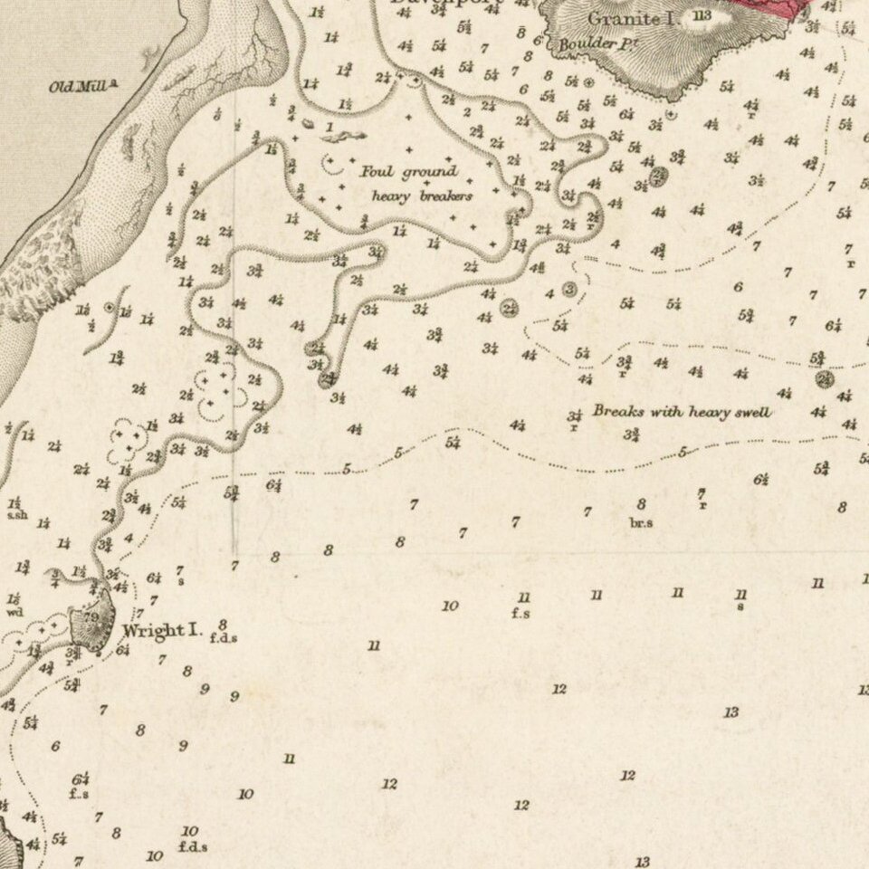
Detailed chart of the coastal region just south of Adelaide and east of Kangaroo Island.
History of The Region
Horseshoe Bay was proclaimed a port in 1851 and the settlement above the bay was named Port Elliot in 1852 after Charles Elliot, the Governor of Bermuda who was a friend of the then Governor of South Australia, Sir Henry Young. The location had been previously known as Freeman's Knob; the aboriginal name for the area may have been "Witengangool".
The port was established to provide a safe seaport for the Murray river trade which terminated at Goolwa, as the Murray Mouth was deemed too treacherous and unpredictable for safe navigation. Goods and passengers were carried between Goolwa and Port Elliot on the first public railway in Australia, completed in 1854. The Government Works to establish the port included Australia's first reticulated water supply. From wells at Waterport to tanks above, the jetty provided fresh water for ships as well as for the town.
In 1864, after a number of disastrous shipping losses in Horseshoe Bay, the railway was extended to Port Victor, which provided safer access for ships. Port Elliot's role as a port ended, with the bay and jetty being left to the fishermen and beachgoers. The importance of the rail link between the river and the sea soon also ended with the building of a railway between Adelaide and Morgan. This enabled river traffic to offload freight and passengers over 160 miles further upstream and rail them directly to Adelaide.
The British Admiralty has produced nautical charts since 1795 under the auspices of the United Kingdom Hydrographic Office (HO). Its main task was to provide the Royal Navy with navigational products and service, but since 1821 it has also sold charts to the public.
In 1795, King George III appointed Alexander Dalrymple, a pedantic geographer, to consolidate, catalogue, and improve the Royal Navy’s charts. He produced the first chart as the Hydrographer to the Admiralty in 1802. Dalrymple, known for his sticky personality, served until his death in 1808, when he was succeeded by Captain Thomas Hurd. The HO has been run by naval officers ever since.
Hurd professionalized the office and increased its efficiency. He was succeeded by the Arctic explorer Captain William Parry in 1823. By 1825, the HO was offering over seven hundred charts and views for sale. Under Parry, the HO also began to participate in exploratory expeditions. The first was a joint French-Spanish-British trip to the South Atlantic, a voyage organized in part by the Royal Society of London.
In 1829, Rear-Admiral Sir Francis Beaufort was appointed Hydrographer Royal. Under his management, the HO introduced the wind force scale named for him, as well as began issuing official tide tables (1833). It was under Beaufort that HMS Beagle completed several surveying missions, including its most famous voyage commanded by Captain FitzRoy with Charles Darwin onboard. When Beaufort retired in 1855, the HO had nearly two thousand charts in its catalog.
Later in the nineteenth century, the HO supported the Challenger expedition, which is credited with helping to found the discipline of oceanography. The HO participated in the International Meridian Conference which decided on the Greenwich Meridian as the Prime Meridian. Regulation and standardization of oceanic and navigational measures continued into the twentieth century, with the HO participating at the first International Hydrographic Organization meeting in 1921.
During World War II, the HO chart making facility moved to Taunton, the first purpose-built building it ever inhabited. In 1953, the first purpose-built survey ship went to sea, the HMS Vidal. Today, there is an entire class of survey vessels that make up the Royal Navy’s Hydrographic Squadron. The HO began to computerize their charts in the late 1960s and early 1970s. In 1968, the compilation staff also came to Taunton, and the HO continues to work from there today.
If you are a student, write to us in telegram: @antiquemaps and indicate what material you need and for what work you need a map in high detail. We are ready to provide material on special terms. For students only!

![[English Edition!] Maris Pacifici quod vulgo Mar del Zud](/map/small/71000.jpg)
