logo

1676. Poli Arctici et terrarum Circumiaccentium Descriptio Novissima Par Fredericum De Wit

  • Poli Arctici et terrarum Circumiaccentium Descriptio Novissima Par Fredericum De Wit

Poli Arctici et terrarum Circumiaccentium Descriptio Novissima Par Fredericum De Wit information:

Year of creation: 
Resolution size (pixels): 
 13466x11906 px
Disk Size: 
 47.1127MiB
Number of pages: 
 1
Place: 
 Amsterdam
Author: 

Print information. Print size (Width x height in inches):
Printing at 72 dpi 
  187.03 х 165.36
Printing at 150 dpi 
 89.77 х 79.37
Printing at 300 dpi 
 44.89 х 39.69

An example of detailing the file of this map of in a printable high-resolution:

Click to open in high resolution (open in new tab).
Attention! this is just the central piece (central area 960x960 px) of the map file!
This is an example, so that you can see and study the level of detail of a given map. The entire Map will be fully available after payment!

Poli Arctici et terrarum Circumiaccentium Descriptio Novissima Par Fredericum De Wit

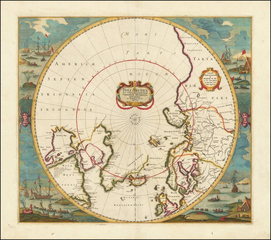
Old color example of Jansson's map of the North Polar regions, newly revised by Frederick De Wit.

The map shows Baffin's Bay, Button's Bay and James Bay, Greenland, Iceland, Spitsberge (with incomplete coastline), Lappland, Russian and European Asia, etc.

Numerous compass roses, sailing ships, etc. Two decorative cartouches.

This is the first De Wit edition of the map, which includes his name in the title cartouche (Fredericum de Wit). A later edition shortens his name to F. De Wit.

Kershaw, K.A. #103; Burden, P.D. #246.

Special conditions for students!

If you are a student, write to us in telegram: @antiquemaps and indicate what material you need and for what work you need a map in high detail. We are ready to provide material on special terms. For students only!

Item information:

Year of creation:
Size:
13466x11906 px
Disk:
47.1127MiB
Number of pages:
1
Place:
Amsterdam
Author:
Frederick De Wit.
$14.99

Related item