Map size in jpg-format: 1.27371MiB
Click to open in high resolution (open in new tab).
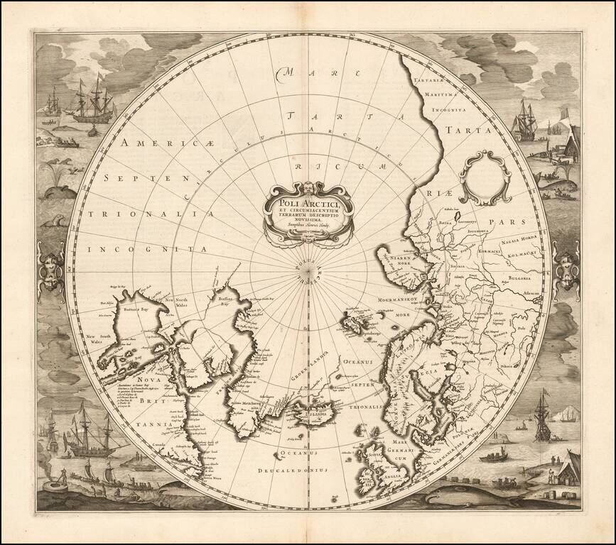
Striking example of Henricus Hondius' map of the North Polar Regions, first issued in 1636.
With the advances in the knowledge of the Arctic, Mercator's map of 1595 had become obsolete by the 1630s. Hondius drew on the cartography of Henry Briggs for his model of Hudson's Bay, supplemented by Thomas James map of 1633. The usual confusion appears around Frobisher's Strait. The prospect of a Northwest Passage is left open, as is the entire Northwestern portion of North America.
Dutch nomenclature appears along the coast of Labrador.
The present example is the first "finished" state of the map. The states can be identified as follows:
Henricus Hondius (1597-1651) was a Dutch engraver and mapmaker, a member of a prominent cartographic family. His father, Jodocus Hondius, was also an engraver and geographer. While working with his father, Henricus was instrumental in the expansion and republishing of Mercator’s atlas, first published in 1595 and republished by Hondius in 1606.
Upon his father’s death in 1612, Henricus and his brother, Jodocus the Younger, took over the business. He set up his own shop in 1621, where he continued to release new editions of the Mercator atlas. Later, he partnered with his brother-in-law, Jan Janssonius, in continuing to expand and publish Mercator’s atlas, which would become known as the Mercator-Hondius-Janssonius atlas. Born and based in Amsterdam, he died there in 1651.
If you are a student, write to us in telegram: @antiquemaps and indicate what material you need and for what work you need a map in high detail. We are ready to provide material on special terms. For students only!
![[Eastern Hemisphere Globe Gores] (Nova et integra universi Orbis descriptio)](/map/small/54480.jpg)

