logo

1800. Plan Geometral De La Ville et Faubourg De Bordeaux Divise en ses Dix Paroisses 1800 . . .

  • Plan Geometral De La Ville et Faubourg De Bordeaux Divise en ses Dix Paroisses 1800 . . .
  • Plan Geometral De La Ville et Faubourg De Bordeaux Divise en ses Dix Paroisses 1800 . . .

Plan Geometral De La Ville et Faubourg De Bordeaux Divise en ses Dix Paroisses 1800 . . . information:

Year of creation: 
Resolution size (pixels): 
 17562x13087 px
Disk Size: 
 74.9288MiB
Number of pages: 
 2
Place: 
 Bordeaux
Author: 

Print information. Print size (Width x height in inches):
Printing at 72 dpi 
  243.92 х 181.76
Printing at 150 dpi 
 117.08 х 87.25
Printing at 300 dpi 
 58.54 х 43.62

An example of detailing the file of this map of in a printable high-resolution:

Click to open in high resolution (open in new tab).
Attention! this is just the central piece (central area 960x960 px) of the map file!
This is an example, so that you can see and study the level of detail of a given map. The entire Map will be fully available after payment!

Plan Geometral De La Ville et Faubourg De Bordeaux Divise en ses Dix Paroisses 1800 . . .

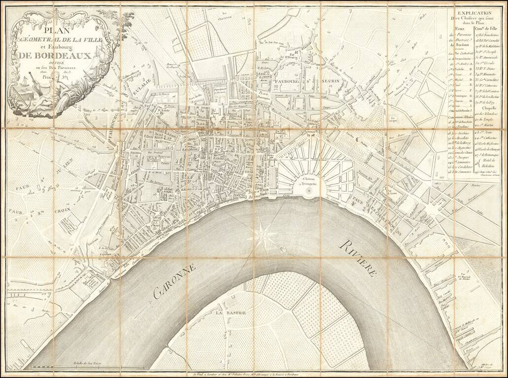
Rare and highly detailed plan of Bordeaux, published and sold by Mrs. Filliatre Frere, a print and bookseller active in Bordeaux in the first half of the 19th century.

The map is apparently quite rare, as we were not able track any other examples having been offered at auction or in dealer catalogs and the map does not appear in the on-line catalog of the BNF.


Special conditions for students!

If you are a student, write to us in telegram: @antiquemaps and indicate what material you need and for what work you need a map in high detail. We are ready to provide material on special terms. For students only!

Item information:

Year of creation:
Size:
17562x13087 px
Disk:
74.9288MiB
Number of pages:
2
Place:
Bordeaux
Author:
Filliatre Frere.
$14.99

Related item