Map size in jpg-format: 47.6964MiB
Click to open in high resolution (open in new tab).
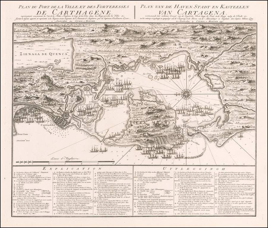
Superb Dutch Broadside Map of Admiral Vernon's Defeat at Cartagena in 1741.
Double-page engraved map of the city of Cartagena, its harbor and surrounding forts, oriented with east at the top, published during the War of Jenkin's Ear.
The map illustrates the various events of the Battle of Cartagena pictorially, showing the English ships in position around the area. A key is provided in French and Dutch with almost 50 points of interest enumerated.
The Battle of Cartagena
The Battle of Cartagena de Indias was an amphibious military engagement between the forces of Britain under Vice-Admiral Edward Vernon and those of Spain under Admiral Blas de Lezo. It took place at the city of Cartagena de Indias, in March 1741, in present-day Colombia. The battle was a significant episode of the War of Jenkins' Ear and a large-scale naval campaign.
Cartagena, in the 18th century, was a large and rich city of over 10,000 people. It was the capital of the province of Cartagena and the main town had significant fortifications that had been recently repaired, increased and improved with outlying forts, batteries and works. Its harbor was considered one of the finest in the world and it served the galleons of the commercial fleet, Galeones a Tierra Firme y Perú, that annually conveyed through Havana to Spain the immense revenues of gold and silver from New Granada and Peru.
Founded by Pedro Heredia in 1533, it had been the target of conquest in the past and was captured by the English, under Francis Drake, in 1585 and by the French, under Baron de Pointis in 1697. The city faces the Caribbean to the west, to the south its bay has two entrances: Boca Chica (Little Mouth) and Boca Grande (Big Mouth). Boca Chica was the only deep water entrance and was so narrow it allowed the passage of only one ship at a time. This entrance was defended on one side by the Fort San Luis with a couple of small outworks on the peninsula of Terra Bomba and on the other side by the fascine battery Baradera.
Beyond Boca Chica was the great lagoon of the outer harbor with an entry channel into the inner harbor between two peninsulas, each defended by a fort. The walls of the city itself mounted some 160 cannon and the suburbs 140 guns. The city was surrounded by a water-filled ditch and its gates supported by recently built bastions. The suburbs were also surrounded by a wall and ditch. About a quarter mile south from the city on a hill was Fort San Lazaro, a square fifty feet on a side with three demi-bastions. The position of Fort San Lazaro commanded the city itself and the plane around the hill. There was also a small hill nearby that commanded Fort Lazaro, but there was no fresh water source available outside Cartagena and the fort. The road from the best landing point, the beach at Texar de Gracias, to Fort Lazaro, was three miles long.
The British invasion force consisted of:
The Spanish force defending Cartagena included:
The expedition and battle lasted for days and ended with the British fleet withdrawing in defeat, with 18,000 dead or incapacitated, mostly by disease. The Spanish also suffered severely from disease including Blas de Lezo himself, who died a few weeks after falling ill from the plague from unburied bodies. In addition, a total of 50 British ships were lost, badly damaged, disabled or abandoned for lack of crews. There were nineteen ships of the line damaged, four frigates and twenty-seven transports lost.
Of the 3,600 American colonists who had volunteered, lured by promises of land and mountains of gold, most died of yellow fever, dysentery, and outright starvation. Only 300 returned home, including Lawrence Washington, who renamed his Virginia plantation, Mount Vernon after Admiral Vernon.
Covens & Mortier was one of the largest and most successful publishing firms in Dutch history and continued in business for over a century. Pierre Mortier the Elder (1661-1711) had obtained a privilege in 1690 to distribute the works of French geographers in the Netherlands. After his widow continued the business for several years, Cornelis (1699-1783) took over in 1719.
In 1721, Mortier forged a partnership with Johannes Covens (1697-1774), who had recently married Cornelis’ sister. They published under the joint name of Covens & Mortier. In 1774, upon the death of his father, Johannes Covens II (1722-1794) took over his father’s share. In 1778, the company changed its name to J. Covens & Zoon, or J. Covens & Son.
Covens II’s son, Cornelis (1764-1825), later inherited the business and brought Petrus Mortier IV back into the fold. Petrus was the great-grandson of Petrus Mortier I. From 1794, the business was called Mortier, Covens & Zoon, or Mortier, Covens, & Son.
The business specialized in publishing French geographers including Deslisle, Jaillot, Janssonius, and Sanson. They also published atlases, for example a 1725 reissue of Frederik de Wit’s Atlas Major and an atlas, with additions, from the works of Guillaume Delisle. There were also Covens & Mortier pocket atlases and town atlases. The company profited from acquiring plates from other geographers as well. For example, the purchased Pieter van der Aa’s plates in 1730. Finally, they also compiled a few maps in house. At their height, they had the largest collection of geographic prints ever assembled in Amsterdam.
If you are a student, write to us in telegram: @antiquemaps and indicate what material you need and for what work you need a map in high detail. We are ready to provide material on special terms. For students only!