logo

1814. Plan de la Ville et Faubourgs de Paris, avec ses Monuments Divise par Quartiers et Arrondissemeents par. J. Bonnisel 1814 . . .

  • Plan de la Ville et Faubourgs de Paris, avec ses Monuments Divise par Quartiers et Arrondissemeents par. J. Bonnisel 1814 . . .

Plan de la Ville et Faubourgs de Paris, avec ses Monuments Divise par Quartiers et Arrondissemeents par. J. Bonnisel 1814 . . . information:

Year of creation: 
Resolution size (pixels): 
 29454x23039 px
Disk Size: 
 265.08MiB
Number of pages: 
 1
Place: 
 Paris
Author: 

Print information. Print size (Width x height in inches):
Printing at 72 dpi 
  409.08 х 319.99
Printing at 150 dpi 
 196.36 х 153.59
Printing at 300 dpi 
 98.18 х 76.8

An example of detailing the file of this map of in a printable high-resolution:

Click to open in high resolution (open in new tab).
Attention! this is just the central piece (central area 960x960 px) of the map file!
This is an example, so that you can see and study the level of detail of a given map. The entire Map will be fully available after payment!

Plan de la Ville et Faubourgs de Paris, avec ses Monuments Divise par Quartiers et Arrondissemeents par. J. Bonnisel 1814 . . .

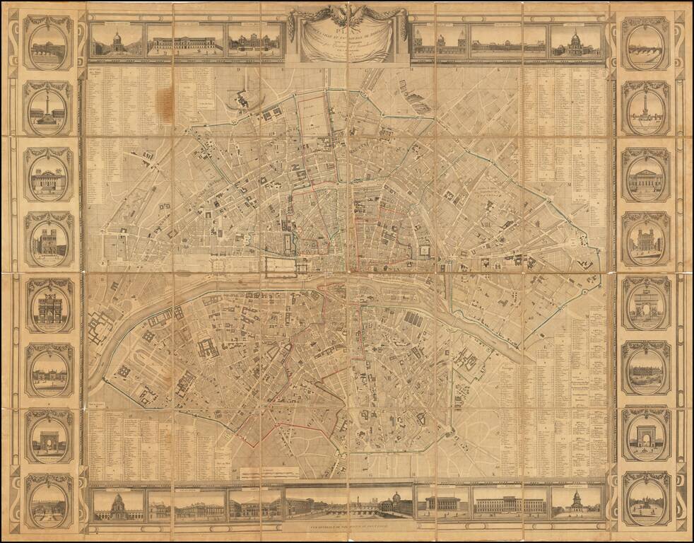
Rare wall map of Paris, issued at the beginning of the 19th Century, several decades before the major projects to re-design Paris under Georges-Eugène Haussmann commenced planning.

The map divides Paris nto 12 arrondissements and 48 districts, published in the year before the Bourbon restoration. The map illustrates the he first works of embellishment and development of roads which had been ordered by Napoleon, including:

  • Canal de l'Ourcq, completed in 1802
  • Canal de Saint-Denis, begun in 1811
  • Bassin de la Villette, intended to supply the capital, completed between 1806 and 1809
  • Abattoirs
  • cemeteries of the North, East, from Vaugirard, from Sainte-Catherine (decree of June 12, 1804)
  • new Morgue place du Marché-Neuf (police order of 1804)
  • Pont des Arts, built between 1802 and 1804
  • Pont d'Austerlitz, between 1799 and 1807
  • Reserve granaries
  • Quai d'Orsay
  • flower market
  • western part of the rue de Rivoli.

On the right bank, facing the Champ de Mars, is the drawing of a "projected palace". This is the Villa Trocadéro, a project by the architect Antoine-François Peyre, which was never carried out.

Around the plan were arranged 29 views of the main Parisian monuments, including the "projected palace" of the villa Trocadéro.

Rarity

The map is scarce. The present example, dated 1814, woiuld seem to be the first edition of the map, which was re-issued in 1815 and 1816.


Special conditions for students!

If you are a student, write to us in telegram: @antiquemaps and indicate what material you need and for what work you need a map in high detail. We are ready to provide material on special terms. For students only!

Item information:

Year of creation:
Size:
29454x23039 px
Disk:
265.08MiB
Number of pages:
1
Place:
Paris
Author:
J. Bonnisel.
$21.99

Related item