Map size in jpg-format: 218.377MiB
Click to open in high resolution (open in new tab).

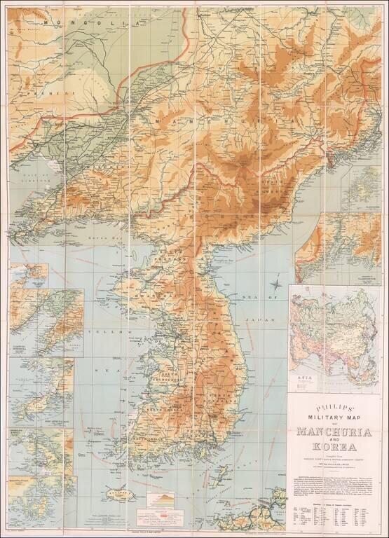
Russo-Japanese War Map of Manchuria and Korea.
Detailed color-lithographed folding map of Korea and Manchuria, published in London for coverage fo the Russo-Japanese War.
The Russo-Japanese War was fought during 1904–1905 between the Russian Empire and the Empire of Japan over rival imperial ambitions in Manchuria and Korea. The war resulted in a Japanese victory and the Treaty of Portsmouth (U.S.A). Teddy Roosevelt was instrumental in the negotiation of the treaty and was awarded the Nobel Peace Prize for his efforts.
The explanatory note under the title elaborates on the geopolitical situation in the pictured territory. It refers to the commencement of the Russian lease of Port Arthur and occupation of Manchuria in 1900.
The map renders topography by gradations of color. It includes the following insets: Port Arthur Harbour; Liaotung Peninsula; Port Arthur & Dalni; Chemulpo & Seoul; Masanpo & Fusan; Vladivostok; Approaches to Vladivostok; and Asia (British, Japanese, Russian, and Chinese Possessions).
At the bottom of the title block is a translation table of transliterated Korean geographical terms.
Steamer routes with mileage are shown in dashed-red lines.
Rarity
One copy located in OCLC, at the University of Maryland, College Park. No copies listed in RBH.
If you are a student, write to us in telegram: @antiquemaps and indicate what material you need and for what work you need a map in high detail. We are ready to provide material on special terms. For students only!
![[Martin Behaim Globe / Book] Pars Globi terrestris Ao. 1492 a Martino Behaim Equite Lusitano Norimbergae confecti Delineavit Christoph. Theoph de Murr 1778 (bound with:) Diplomatische Geschichte des Portugesischen berühmten Ritters Martin Behaims](/map/small/68828.jpg)
![Il Disegno Della Terza Parte Dell' Asia [Gastaldi's Wall Map of SE Asia with extra panels!]](/map/small/30554hbp.jpg)
![Chinae, olim Sinarum regionis nova descriptio. auctore Ludouico Georgio. [English Edition!]](/map/small/71123.jpg)