Map size in jpg-format: 207.465MiB
Click to open in high resolution (open in new tab).
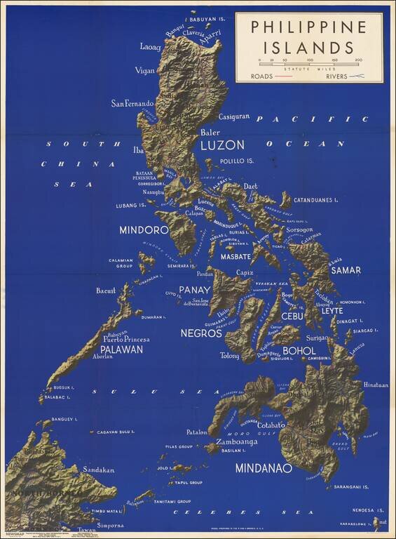
Fine large map of the Philippine Islands, published to provide information during World War II.
Newsmap was a production of the Special Service Division Army Service Forces, War Department.
Color map on one side, two color maps and text on verso. Light wear to corners of folded map resulting in some separation starting at fold intersections, couple of small pinholes in borders. The map is very crisp and clean, hardly ever opened. On one side is a very large aerial physical map of the Philippine Islands (scale approximately 4 1/2 inches to 100 miles) with roads and rivers marked.
If you are a student, write to us in telegram: @antiquemaps and indicate what material you need and for what work you need a map in high detail. We are ready to provide material on special terms. For students only!
![[Martin Behaim Globe / Book] Pars Globi terrestris Ao. 1492 a Martino Behaim Equite Lusitano Norimbergae confecti Delineavit Christoph. Theoph de Murr 1778 (bound with:) Diplomatische Geschichte des Portugesischen berühmten Ritters Martin Behaims](/map/small/68828.jpg)
![Il Disegno Della Terza Parte Dell' Asia [Gastaldi's Wall Map of SE Asia with extra panels!]](/map/small/30554hbp.jpg)
![Chinae, olim Sinarum regionis nova descriptio. auctore Ludouico Georgio. [English Edition!]](/map/small/71123.jpg)