Map size in jpg-format: 36.6564MiB
Click to open in high resolution (open in new tab).
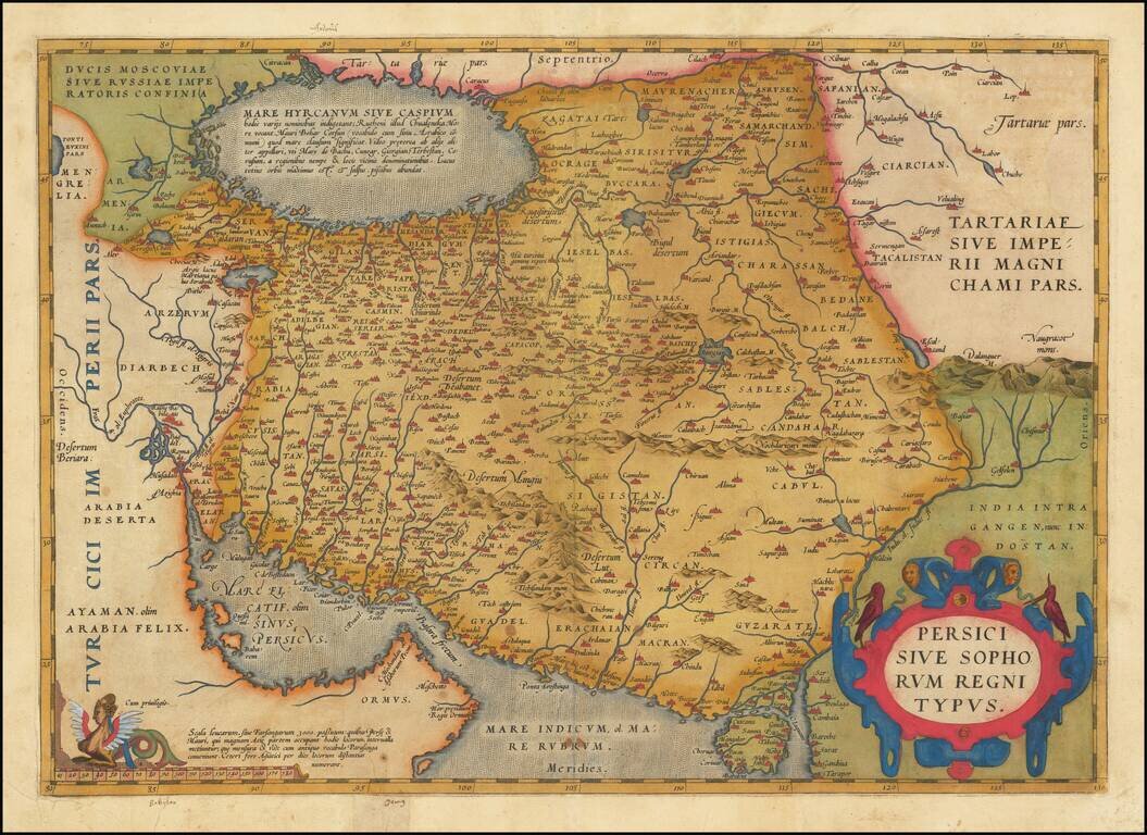
Fine Ortelius Map of Persia from the World’s First Modern Atlas
Highly-influential and beautifully-detailed map of Persia from Abraham Ortelius' Theatrum Orbis Terrarum, the first modern atlas of the world.
The map shows the Persian Gulf and the eastern portion of the Arabian Peninsula. At center is what is today the country of Iran and is here Persia. To the east is a bit of what is today Afghanistan and Pakistan and here is labeled as parts of Tartary and India. The land is covered in settlements (marked with a building sign), rivers, and mountain ranges.
The Caspian Sea features prominently, yet it is shown horizontally and indefinitely. Within the body of water is a block of text. It translates to:
The Hyrcanian or Caspian sea is nowadays referred to by various names; the Ruthenians call it Chualenska More, and the Mauri call it Bobar Corsun (the same word as the one they use for the Arabic Gulf), which means enclosed sea. I observe that it is called differently by others, such as Mare de Bachu, Cunzar, Giorgian, Terbestan, and Corusum after the names of adjacent areas and places. It is the largest lake in the entire world, and has salt water. It has fish in abundance.
The map contains a few decorative elements as well. In the lower right is a title cartouche. Birds perch on the strapwork which is characteristic of Ortelius’ style. In the lower right is the scale bar, which is topped with a well-endowed, winged mermaid. The text in the bottom left corner reads:
Scale of miles or Farsangæ of 3000 strides with which the Persians and Maures, who occupy a large part of Asia, measure the distance between places. Both the measure and its name correspond with the ancient [Greek] parasanga. The other Asians usually measure distances in days.
These text blocks reveal the depth of research that Ortelius performed in making his maps. This map draws particularly on a map of Asia Minor by Giacomo Gastaldi from 1564, as well as Ortelius’ earlier map of Asia, dated 1567.
This map was included in Ortelius’ important 1570 atlas, Theatrum Orbis Terrarum, the world’s first modern atlas. It was printed in three states, although the changes between states was minimal, and appeared in atlases from 1570 until the mid-seventeenth century.
The map includes marvelous detail for the period and would be a fine addition to any Ortelius or Persian map collection.
If you are a student, write to us in telegram: @antiquemaps and indicate what material you need and for what work you need a map in high detail. We are ready to provide material on special terms. For students only!

![Азіятская Турція, Персія, Аравія, и Часть Туркестана. [Asian Turkey, Persia, Arabia, and Part of Turkestan.]](/map/small/66732.jpg)