logo

1935. Paul Bunyan's pictorial map of the United States Depicting Some of his Deeds and Exploits By R. D. Handy

  • Paul Bunyan's pictorial map of the United States Depicting Some of his Deeds and Exploits By R. D. Handy

Paul Bunyan's pictorial map of the United States Depicting Some of his Deeds and Exploits By R. D. Handy information:

Year of creation: 
Resolution size (pixels): 
 18903x12745 px
Disk Size: 
 82.3435MiB
Number of pages: 
 1
Place: 
 St. Paul, MN
Author: 

Print information. Print size (Width x height in inches):
Printing at 72 dpi 
  262.54 х 177.01
Printing at 150 dpi 
 126.02 х 84.97
Printing at 300 dpi 
 63.01 х 42.48

An example of detailing the file of this map of in a printable high-resolution:

Click to open in high resolution (open in new tab).
Attention! this is just the central piece (central area 960x960 px) of the map file!
This is an example, so that you can see and study the level of detail of a given map. The entire Map will be fully available after payment!

Paul Bunyan's pictorial map of the United States Depicting Some of his Deeds and Exploits By R. D. Handy

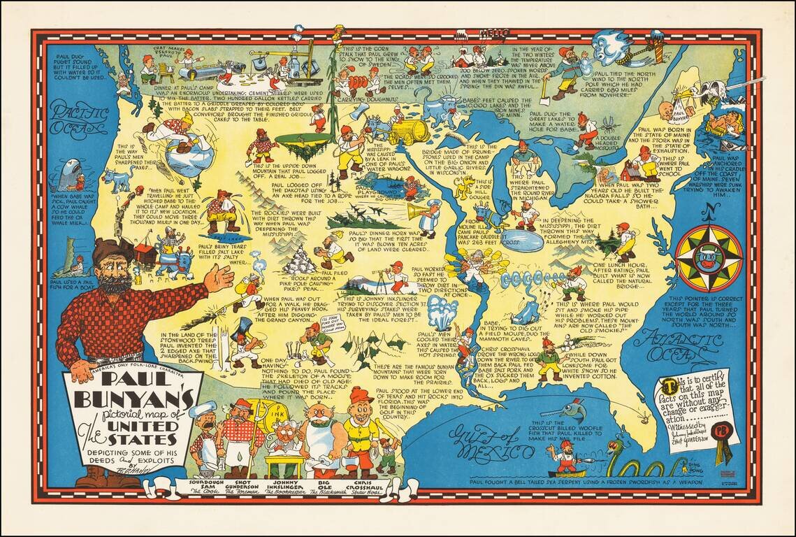
Rare pictorial map of the United States, celebrating the legend of Paul Bunyan.

As noted by David Rumsey:

Humorous pictorial map by R. D. Handy showing the adventures [of Paul Bunyan] across the United States, with illustrations and descriptive notes. Paul Bunyan, holding title cartouche on lower left. Includes illustrations "Beginning of Golf in this Country" when Paul stood at the lower end of Texas and hit rocks into Florida, and compass rose in right margin, "This pointer is correct except for the three years that Paul turned the world around so North was south and south was north". Notes: "This is to certify that all of the facts on this map are without any change or exaggeration ... Witnessed by Johnny Inkslinger Shot Gunerson.

A few other legends include:

  • In school Paul used a slab of lime stone for a slate and a big white pine tree for a pencil.
  • The 10,000 lakes in the State of Minnesota fill the footprints of Paul's gigantic Blue Ox, Babe who measured forty-two ax handles wide between the eyes.
  • The Mississippi River was the result of water leaking from one of Paul's water storage barrels.
  • Paul's briny tears filled the Great Salt Lake of Utah.
  • When Paul sat down for a smoke to think about his problems, he set off the Great Smokey Mountains.
  • When Babe when digging after a field mouse, he created famous Mammoth Caves.

​R. D. Handy was a cartoonist working for the Duluth New-Tribune. In 1919, he had apparently risen to General Manager. His work seems to have started as a cartoonist as early as about 1900.

States of the Map

We are aware of two states of the map:

  • One dated 1935 at bottom right corner
  • One with the extra imprint in red at bottom right corner "Published by R.D. Handy Duluth, MN".

Special conditions for students!

If you are a student, write to us in telegram: @antiquemaps and indicate what material you need and for what work you need a map in high detail. We are ready to provide material on special terms. For students only!

Item information:

Year of creation:
Size:
18903x12745 px
Disk:
82.3435MiB
Number of pages:
1
Place:
St. Paul, MN
Author:
R. D. Handy.
$14.99

Related item