logo

1947. Official Sightseeing Map of Southern California

  • Official Sightseeing Map of Southern California
  • Official Sightseeing Map of Southern California

Official Sightseeing Map of Southern California information:

Year of creation: 
Resolution size (pixels): 
 13605x21192 px
Disk Size: 
 74.3004MiB
Number of pages: 
 2
Place: 
 Los Angeles

Print information. Print size (Width x height in inches):
Printing at 72 dpi 
  188.96 х 294.33
Printing at 150 dpi 
 90.7 х 141.28
Printing at 300 dpi 
 45.35 х 70.64

An example of detailing the file of this map of in a printable high-resolution:

Click to open in high resolution (open in new tab).
Attention! this is just the central piece (central area 960x960 px) of the map file!
This is an example, so that you can see and study the level of detail of a given map. The entire Map will be fully available after payment!

Official Sightseeing Map of Southern California

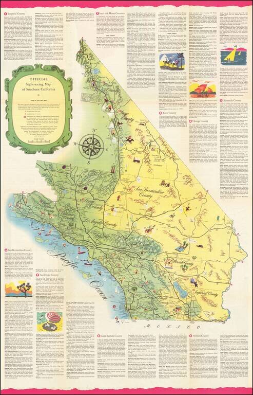
Rare Sightseeing Map of Southern California.

The map combines pictorial vignettes with a tourist road map of the region, with text describing tourist opportunities in each of Southern California's counties.

On the verso, a sightseeing map of Los Angeles County with sightseeing tips for the Los Angeles Basin.

Rarity

We were unable to find another example of this map.


Special conditions for students!

If you are a student, write to us in telegram: @antiquemaps and indicate what material you need and for what work you need a map in high detail. We are ready to provide material on special terms. For students only!

Item information:

Year of creation:
Size:
13605x21192 px
Disk:
74.3004MiB
Number of pages:
2
Place:
Los Angeles
Author:
All Year Club of Southern California.
$21.99

Related item