Map size in jpg-format: 40.06MiB
Click to open in high resolution (open in new tab).
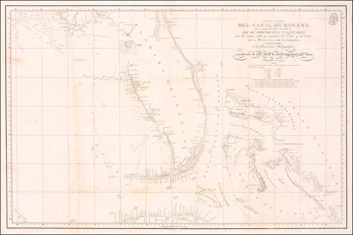
A Landmark Spanish Chart of Florida and the Bahamas
Important early 19th Century Sea chart of Florida and the Bahamas, one of the earliest Spanish Sea Charts to focus on the coast of Florida and the Bahamas.
The map offered here is identified as originally published in 1805 and corrected to 1807 and is almost certainly the first detailed map of the region published by the Spanish Hydrographical Office. The map is based largely upon the observations of Dionisio Galiano in the ship San Fulgencio (1799).
The Spanish agency, the Dirección de Hidrografía, was set up in the late 18th century to disseminate accurate sailing information, about the same time as the British with their Hydrographic branch of the Royal Navy. The Spanish were of course the first major sponsors of discovery in the Caribbean, the Gulf of Mexico and mainland Florida. As far back as the beginning of the16th century they had started compiling cartographic information on these regions although the information was maintained as a national secret. Much of the British and French information was published privately.
Rarity
The map is very rare. OCLC locates copies of the 1807 edition of the map at the Biblioteca Nacional de Espana, British Library, Bayerische Staatbibliothek, University of Michigan and University of Texas, Arlington.
The Biblioteca Nacional de Espana may also have an example of the 1805 edition, although the entry on line is not clear on the date.
The Dirección de Hidrografía, or the Directorate of Hydrographic Works, was established in 1797. Its roots were in the Casa de Contratación, founded in 1503 in Sevilla, which housed all the charts of the Spanish Empire and oversaw the creation and maintenance of the padrón real, the official master chart. The Casa, now in Cadiz, was shuttered in 1790, but Spain still needed a hydrographic body. In response, the Dirección was created in 1797. One of its first projects was the publication of charts from the Malaspina Expedition (1789-1794). The Dirección oversaw not only publication, but also surveying. The Dirección was abolished in the early twentieth century, when their work was distributed to other organizations.
If you are a student, write to us in telegram: @antiquemaps and indicate what material you need and for what work you need a map in high detail. We are ready to provide material on special terms. For students only!

![[Wall Map] West-Indische Paskaert waer in de graden der breedde over weder zyden vande middelyn wassende so vergrooten dat die geproportioneert syn tegen hunne nevenstaende graden de lengde.](/map/small/60169.jpg)
