Map size in jpg-format: 17.9166MiB
Click to open in high resolution (open in new tab).
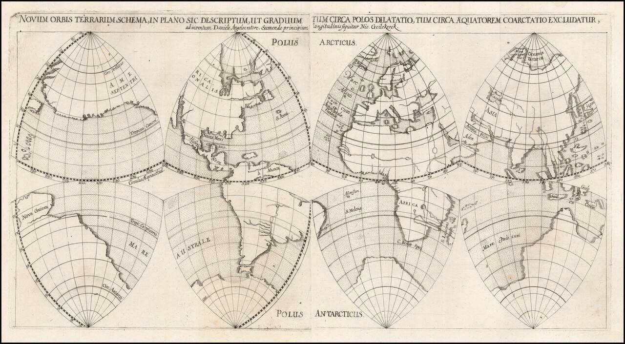
Unusual Seventeenth-Century World Map Projection
Highly unusual gore map of the world by German minister, mapmaker, and surveyor Daniel Angelocrator, employing a projection apparently of his own invention or adaptation. The map is derived from the work of Dutch cartographer Nicolaes van Geelkercken.
The map shows the world divided into eight equilateral spherical triangles. The top four show the northern hemisphere and the bottom four the southern, although they are grouped on two pages as eastern and western hemispheres as well.
The southern hemisphere is rimmed with a massive southern continent that includes New Guinea. The top left triangle shows the extreme westward extension of North America, causing the North Pacific to become very narrow. This is a noted characteristic of Geelkercken’s 1616 world map, whose geography was the model for Angelocrator’s work.
In the present map, land masses are delineated with shading at their edges, while bodies of water stippled with a uniform dotted pattern. Major lakes and rivers snake across land masses.
The present map was issued with two other sheets, which group the octants into northern and southern hemisphere grouped around the poles; together, the four sheets comprise were part of Angelocrator’s 1628 work, Doctrina de Ponderibus, Monetis et Mensuris per Totum Terrarum Orbem Usitatis, printed by Johann Nicolaus Stoltzenberger. The work discusses surveying techniques, solid and liquid substances, ancient and modern weights, precious metals, and money.
World Map Projections in the Renaissance
During the Renaissance, rapidly expanding geographical knowledge of the world necessitated new ways to depict the globe. Mapmakers starting in the late fifteenth century worked to modify Ptolemy’s projections of the oikumene, or known world, to create maps that depicted the whole world. With Portuguese exploration of the Southern Hemisphere and the Americas starting in the fifteenth century, new map projections were needed to accurately depict the effective doubling of the world.
According to Snyder, “The map could be expanded in three main ways: by simply doubling the traditional circular representation of a hemisphere; by geometrically projecting the whole world into a single geometric figure, such as a rectangle or an oval; or by splitting the world into a number of small geometric pieces (gores) that could be used to make globes.” It is this last method that Angelocrator used in the present map, dividing the world into eight equilateral spherical triangles, or octants, four of which are seen in the present map.
The earliest extant globes, from the late fifteenth century, did not actually require projection, as the spherical surfaces were painted on directly. Starting in the sixteenth century, though, globes were made by pasting strips (gores) onto a ball. These gores could be of various thicknesses and could either extend from pole to pole or pole to equator (as in the case of the present map), usually along meridians ten to thirty degrees apart. This method was also projected onto paper maps.
One of the first uses of spherical octants can be seen in a ca. 1514 mappamundi controversially and uncertainly attributed to Leonardo da Vinci, which groups the octants in fours around each pole, as in the present map. While this map did not show intermediate meridians or parallels, a 1551 map by French mathematician and cartographer Oronce Finé added meridians and parallels as circular arcs within each octant. This technique can be seen in the present map. Angelocrator uses this unusual method of gore globe projection to portray the world from a unique perspective.
If you are a student, write to us in telegram: @antiquemaps and indicate what material you need and for what work you need a map in high detail. We are ready to provide material on special terms. For students only!


