Map size in jpg-format: 25.5588MiB
Click to open in high resolution (open in new tab).
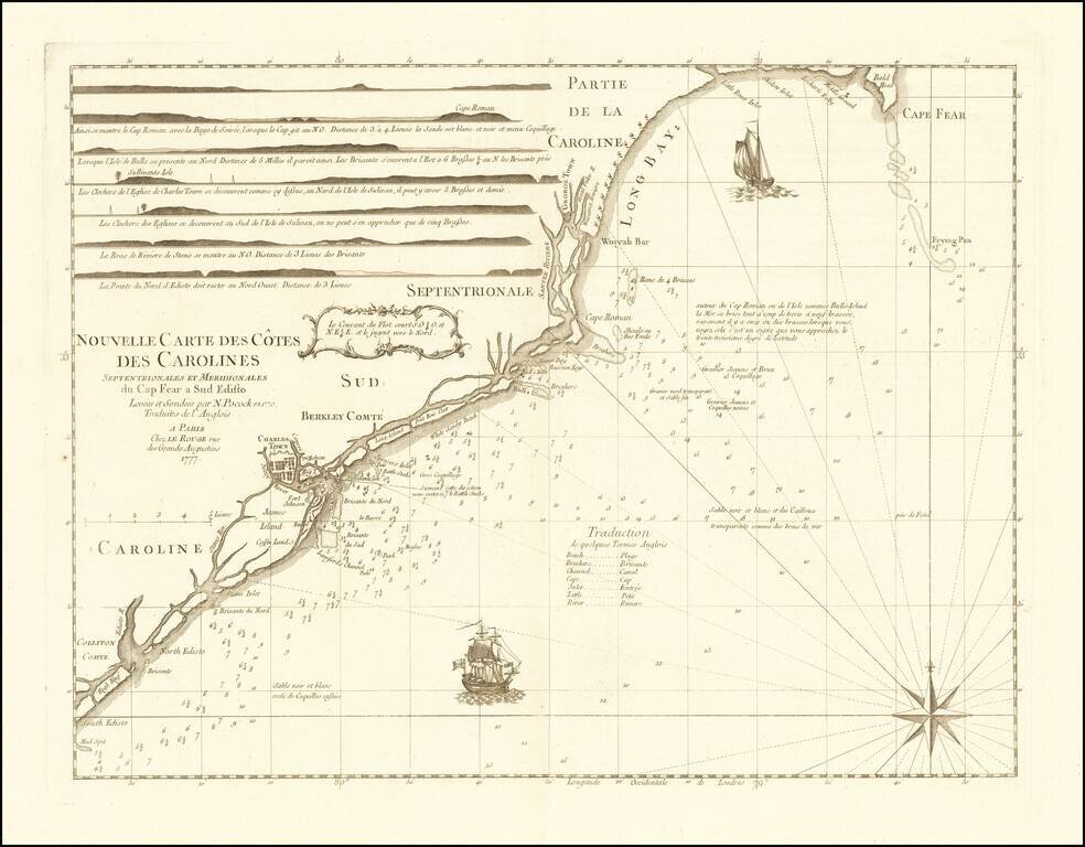
Rare chart of the Carolina coast, prepared by Le Rouge in connection with France's participation in the American Revolutionary War.
This rare chart is one of a group of charts prepared by Georges Louis Le Rouge for use by the French Navy, which entered the Revolutionary War. The map shows the region from Cape Fear to South Edisto Island, along with small town plans for Charleston and Georgetown.
This chart was included in Le Rouge's Atlas Ameriquain Septentrionale, based on manuscript charts produced by Nathaniel Pocock. The true identity of Pocock and the location of any of his charts has remained an enigma for historians. Nevertheless, the map features relatively advanced hydrographic information, including depth soundings and bearing lines to major landmarks and lighthouses. The chart features seven very attractive mariner's views of the coast, and the sea is embellished with two frigates under full sail and is traversed by rhumb lines that radiate from a compass rose. Examples of this chart would have been used at sea by French officers, as their navy engaged British ships on numerous occasions off of the Carolina coast. A nice example of this rare chart.
George-Louis Le Rouge (1712-1790), though known for his work in Paris, was originally born Georg Ludwig of Hanover, Germany. He grew up and was educated in Hanover, after which he became a surveyor and military engineer. Around 1740, however, Le Rouge moved to Paris and set up shop as an engraver and publisher on the Rue des Grands Augustins. It was at this time that he changed his name, adopting a French pseudonym that would later become quite famous.
Le Rouge spent much of his forty-year career translating various works from English to French, and his cartographic influence often came from English maps. His experience as a surveyor and engineer in Germany made him a skilled and prolific cartographer, and he produced thousands of charts, maps, atlases, and plans. His work spans from garden views and small-town plans to huge, multiple-continent maps. Le Rouge eventually accepted the position of Geographical Engineer for Louid XV, the King of France.
Later in life, Le Rouge became well-known for publishing North American maps, such as in his Atlas ameriquain septentrional of 1778. One of Le Rouge’s other more famous works is the Franklin/Folger chart of the Gulf Stream, which he worked on with Benjamin Franklin. Franklin and Le Rouge corresponded around 1780 and collaborated to create this map, a French version of Franklin’s famous chart which was originally printed in 1769.
If you are a student, write to us in telegram: @antiquemaps and indicate what material you need and for what work you need a map in high detail. We are ready to provide material on special terms. For students only!


![[The First Maps in a la poupée Printed Color] Cartes en Couleur des Lieux Sujets aux tremblements de Terre Dans toutes les parties du Monde Selon le Sisteme de l’impulsion Solaire](/map/small/52293op.jpg)