Map size in jpg-format: 142.991MiB
Click to open in high resolution (open in new tab).

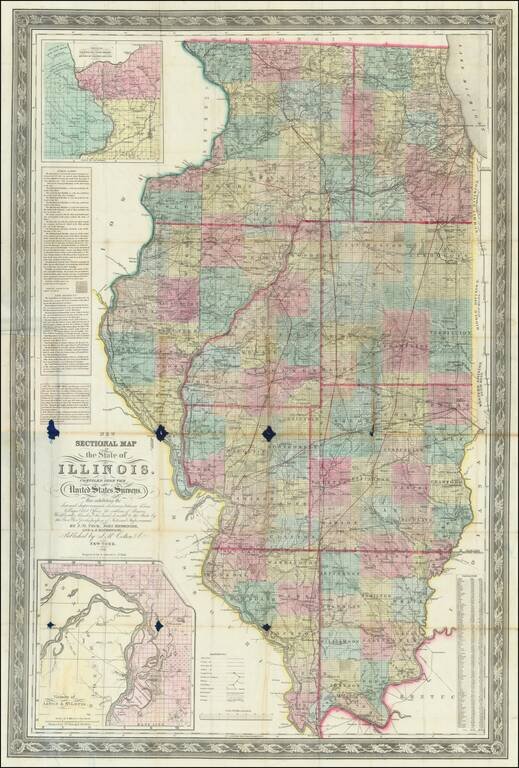
1852 edition of Peck & Messinger's map of Illinois, hand colored by County, published in 1852.
Peck & Messenger's map of Illinois was one of the most enduring map legacies of the midwest, with issues dated as early as 1836 and still in currency some 40 years later.
Includes a decorative border and large insets of the area around Galena and the Lead Regions, and the area around St. Louis. The extent of the township surveys in the state is well defined, as are the many early railroads.
Peck and Messinger were early residents of Illinois, who created one of the earliest maps of the state published west of the Alleghany Mountains and several of the earliest separately published maps to focus on the State of Illinois.
John Mason Peck (1789-1858) was an American Baptist Missionary, who would go on to become one of St. Louis's leading citizens. In the 1820's, he founded one of the first Protestant churches west of the Mississippi, the first college in Illinois, and ordained the first African-American clergy in St. Louis. He also established the first schools for slaves in St. Louis. He was a great publicist for the region and encouraged settlement back east through his famous gazetteer for Missouri and Illinois, and wrote many other books which celebrated the pioneer spirit and history of the area.
John Messinger (1771-1846), was an early settler at Clinton Hill, Illinois (St. Clair County), two and a half miles north of Belleville and kept the first post office in the county outside of Cahokia. Messinger was an accomplished surveyor and surveyed a large portion of the land in this and adjoining counties. In 1783 he moved to Vermont and learned the carpenter's trade and also became a millwright. He came to Kentucky in 1799, and from there to New Design, where he lived a few years and then settled permanently at Clinton Hill.
Beginning in 1806, Messenger was one of the surveyors to survey a portion of the future state of Illinois into townships. He surveyed much of the public domain in both St. Clair and Randolph Counties. He wrote and published, in 1821, a book entitled A Manual or Hand-Book of Practical Surveying. Messenger first encountered John Mason Peck at Dr. Peck's Seminary at Rock Spring. In 1815, he was made a deputy under the Surveyor-General of Ohio, with authority to survey the military tract in the forks of the Mississippi and Illinois Rivers. Later he was appointed to assist in the survey of the northern limits of Illinois, and he made a part of the astronomical and mathematical calculations by which the line dividing the states of Illinois and Wisconsin was located.
Messinger and Philip Creamer made surveyors' compasses that were as well calculated and as well finished in workmanship as any made in the United States. Messenger was a member of the convention that met at Kaskaskia and framed the first constitution of Illinois. He was also a member of the first general assembly of Illinois, which convened in 1818, and in its organization was elected speaker of the House of Representatives.
John Mason Peck (1789-1858) was and American Baptist Missionary, who would go on to become one of St. Louis's leading citizens. In the 1820’s, he founded one of the first Protestant churches west of the Mississippi, the first college in Illinois, and ordained the first African-American clergy in St. Louis. He also established the first schools for slaves in St. Louis. He was a great publicist for the region and encouraged settlement back east through his famous gazetteer for Missouri and Illinois, and wrote many other books which celebrated the pioneer spirit and history of the area.
If you are a student, write to us in telegram: @antiquemaps and indicate what material you need and for what work you need a map in high detail. We are ready to provide material on special terms. For students only!